IMAGES TAKEN NEAR TO
Somerset Road, BOURNEMOUTH, BH7 6JH
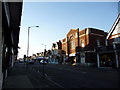
Introduction
This page details the photographs taken nearby to Somerset Road, BH7 6JH by members of the Geograph project.
The Geograph project started in 2005 with the aim of publishing, organising and preserving representative images for every square kilometre of Great Britain, Ireland and the Isle of Man.

There are currently over 7.5m images from over14,400 individuals and you can help contribute to the project by visiting https://www.geograph.org.uk
Image Map
Images are licensed for reuse under creativecommons.org/licenses/by-sa/2.0
Notes
- Clicking on the map will re-center to the selected point.
- The higher the marker number, the further away the image location is from the centre of the postcode.
Image Listing (133 Images Found)
Images are licensed for reuse under creativecommons.org/licenses/by-sa/2.0
Image
Details
Distance
1

Rosebery Park Baptist Church, Pokesdown
Erected in 1951.
Image: © Michael FORD
Taken: Unknown
0.03 miles
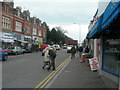
2
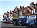
Boscombe East: Rosebery Park Baptist Church
Looking along the main shopping street, Christchurch Road. The name Rosebery Park sounds like a suburb name but I do not know of any other reference to it, apart from Rosebery Road nearby.
Image: © Chris Downer
Taken: 26 Dec 2008
0.04 miles
3
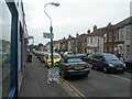
Somerset Road, Boscombe
Photographer was standing on corner of Christchurch Road, looking North.
Image: © Danny P Robinson
Taken: 11 Mar 2006
0.04 miles
4
Christchurch Road, Boscombe (2)
This picture was taken at the junction of Somerset Road, photographer was facing Boscombe town centre.
Image: © Danny P Robinson
Taken: 11 Mar 2006
0.04 miles
5

Rosebery Park Baptist Church
Image seen across Christchurch Road. http://www.roseberypark.org.uk/ implies that the building dates from 1951.
Image: © Derek Harper
Taken: 10 Mar 2010
0.05 miles
8
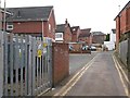
Boscombe East: substation on Warwick Place
Warwick Place is a rear access driveway for even numbered shops 834-892 Christchurch Road (to our left) and the flats above. It also forms a public right of way, footpath G06 between Warwick and Hannington Roads.
Here we see an electricity substation as the lane approaches Warwick Road, its western end.
See Image for the view towards us from ahead, and Image for the next view on the lane behind us, with links to further photos along the route.
Image: © Chris Downer
Taken: 25 Feb 2017
0.06 miles
9
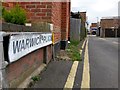
Boscombe East: the Warwick Place sign
Warwick Place is a rear access driveway for even numbered shops 834-892 Christchurch Road (to our right) and the flats above. It also forms a public right of way, footpath G06 between Warwick and Hannington Roads.
Here we view it from its western end, on Warwick Road.
See Image for the next view on the lane, with links to further photos along the route.
Image: © Chris Downer
Taken: 25 Feb 2017
0.06 miles
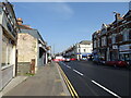
10
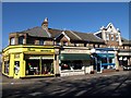
Premises on Christchurch Road, Boscombe
A menswear shop, an Italian restaurant and a copyshop next to the junction with Gloucester Road.
Image: © Derek Harper
Taken: 10 Mar 2010
0.07 miles