IMAGES TAKEN NEAR TO
Corhampton Road, BOURNEMOUTH, BH6 5NY
Introduction
This page details the photographs taken nearby to Corhampton Road, BH6 5NY by members of the Geograph project.
The Geograph project started in 2005 with the aim of publishing, organising and preserving representative images for every square kilometre of Great Britain, Ireland and the Isle of Man.

There are currently over 7.5m images from over14,400 individuals and you can help contribute to the project by visiting https://www.geograph.org.uk
Image Map
Images are licensed for reuse under creativecommons.org/licenses/by-sa/2.0
Notes
- Clicking on the map will re-center to the selected point.
- The higher the marker number, the further away the image location is from the centre of the postcode.
Image Listing (28 Images Found)
Images are licensed for reuse under creativecommons.org/licenses/by-sa/2.0
Image
Details
Distance
1
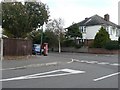
Iford: postbox № BH6 267, Corhampton Road
A George V-reign postbox on the corner of Corhampton and Warnford Road. These roads are typical of those in this area, in being named after villages in southern Hampshire.
Image: © Chris Downer
Taken: 25 Oct 2008
0.04 miles
2
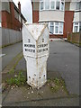
Old Milepost by the A35, Christchurch Road, Pokesdown
Cast iron post by the A35, in parish of BOURNEMOUTH (BOURNEMOUTH District), Christchurch Road, Pokesdown, by No. 1263, against wall, on South-east side of road. Armfield iron casting, erected by Hampshire County Council in the 19th century.
Inscription reads:-
: 3 / BOURNE / MOUTH : : 2 / CHRIST / CHURCH :
Maker:-
: Armfield & Co :
Milestone Society National ID: HA_BMCC03.
Image: © Milestone Society
Taken: 6 Mar 2017
0.04 miles
3
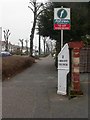
Iford, milepost
Recently repainted milepost on Christchurch Road, probably the last remaining mile marker in the borough. Cast-iron, cast by Armfield of Ringwood; legend on the other side reads "3 / BOURNE / MOUTH". This section of road has wide tree-lined verges; trees have recently had short back and sides.
Image: © Mike Faherty
Taken: 24 Feb 2009
0.05 miles
4
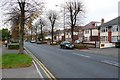
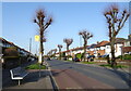
Christchurch Rd, Pokesdown, Bournemouth
This road used to be the main route east from the centre of Bournemouth before large dual carriageway was built. This is looking SW near Warnford Rd.
Image: © Nigel Mykura
Taken: 4 Nov 2008
0.08 miles
8
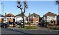
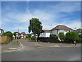
Colemore Road, Bournemouth
Colemore Road is a residential road in the north-eastern suburbs of Bournemouth.
Image: © Malc McDonald
Taken: 21 Jun 2022
0.13 miles
9
Ovington Road, Bournemouth
Ovington Road is a residential road in the north-eastern suburbs of Bournemouth.
Image: © Malc McDonald
Taken: 21 Jun 2022
0.14 miles
10
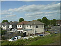
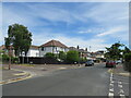
Houses in Iford
This is the back of houses in Southwick Rd close to the junction with Clingan Road, taken from a train on the South West Main Line just east of Pokesdown Station.
Image: © Nigel Mykura
Taken: 7 Jun 2015
0.16 miles