IMAGES TAKEN NEAR TO
Cranleigh Close, BOURNEMOUTH, BH6 5LD
Introduction
This page details the photographs taken nearby to Cranleigh Close, BH6 5LD by members of the Geograph project.
The Geograph project started in 2005 with the aim of publishing, organising and preserving representative images for every square kilometre of Great Britain, Ireland and the Isle of Man.

There are currently over 7.5m images from over14,400 individuals and you can help contribute to the project by visiting https://www.geograph.org.uk
Image Map (Loading...)


Getting Data...Please wait
Leaflet Map data © OpenStreetMap
Images are licensed for reuse under creativecommons.org/licenses/by-sa/2.0
Notes
- Clicking on the map will re-center to the selected point.
- The higher the marker number, the further away the image location is from the centre of the postcode.
Image Listing (75 Images Found)
Images are licensed for reuse under creativecommons.org/licenses/by-sa/2.0
Image
Details
Distance
1
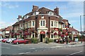
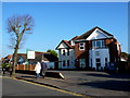
The Athelstan at Tuckton
This traditional, early 20th century pub is at the junction of Cranleigh Road and Athelstan Road in west Tuckton.
Image: © mike smith
Taken: 13 Aug 2007
0.06 miles
2
Tuckton: The Athelstan
One of several Eldgridge Pope & Co. pubs which have been modernised and dropped part of their names – this was originally the Athelstan Arms but the Arms has been dropped. It is on the corner of Cranleigh and Athelstan Roads.
Image: © Chris Downer
Taken: 2 Feb 2008
0.06 miles
3
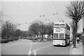
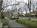
Bournemouth Corporation trolleybus on Cranleigh Road ? 1969
On service 23 to Tuckton Bridge where it would change to service 22 to return to Bournemouth Square via Southbourne.
This is the junction of Cranleigh Road with Carbery Avenue where there was a circle of wiring enabling vehicles to turn back from either direction, but only used in special circumstances. The junction has since been remodelled with all traffic using the roadway behind the island with its trees. http://www.geograph.org.uk/photo/719537 http://www.geograph.org.uk/photo/3402382
This is one of a series of views featuring buses in the 60s, 70s, and 80s. http://www.geograph.org.uk/search.php?i=137652761
Image: © Alan Murray-Rust
Taken: 19 Apr 1969
0.07 miles
4
Kings Castle Montessori School
This large house on Saxonbury Rd has been converted to a Montessori school and baby nursery.
Image: © Nigel Mykura
Taken: 15 Nov 2011
0.07 miles
6
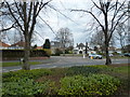
Tuckton: eastern end of Carbery Avenue
Looking along Image from its easternmost junction. Here, Cranleigh Road goes off to the right as we look, while a similar arm to the left is Tuckton Road, which continues behind the camera.
Image: © Chris Downer
Taken: 9 Mar 2008
0.07 miles
7
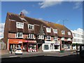
Tuckton: 127-133 Tuckton Road
An unusual looking parade of shops in Tuckton Road. Thresher's off licence has occupied no.129 for at least 35 years.
Image: © Chris Downer
Taken: 9 Mar 2008
0.07 miles
8
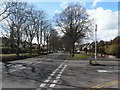
Looking from The New Church, Tuckton across Carbery Avenue to Cranleigh Road
Image: © Basher Eyre
Taken: 5 Apr 2013
0.08 miles
9
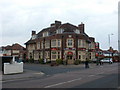
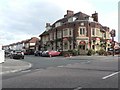
Tuckton, The Athelstan
Pub at the junction of Cranleigh and Athelstan Roads, dated 1931 on a foundation stone. Internally, central bar, with drinking and eating areas on three sides. Cask ales on offer at my visit: Ringwood Best, Boondoggle & Fortyniner. For some customer comments, see http://www.beerintheevening.com/pubs/s/27/2752/Athelstan_Arms/Tuckton
Image: © Mike Faherty
Taken: 5 May 2010
0.08 miles