IMAGES TAKEN NEAR TO
Paisley Road, BOURNEMOUTH, BH6 5FH
Introduction
This page details the photographs taken nearby to Paisley Road, BH6 5FH by members of the Geograph project.
The Geograph project started in 2005 with the aim of publishing, organising and preserving representative images for every square kilometre of Great Britain, Ireland and the Isle of Man.

There are currently over 7.5m images from over14,400 individuals and you can help contribute to the project by visiting https://www.geograph.org.uk
Image Map
Images are licensed for reuse under creativecommons.org/licenses/by-sa/2.0
Notes
- Clicking on the map will re-center to the selected point.
- The higher the marker number, the further away the image location is from the centre of the postcode.
Image Listing (89 Images Found)
Images are licensed for reuse under creativecommons.org/licenses/by-sa/2.0
Image
Details
Distance
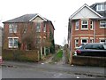
1
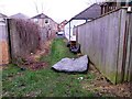
West Southbourne: fly-tipped mattress on footpath H08
Looking along this short public footpath which runs from Kimberley Road (ahead) to a further footpath, H07, on which we are standing, which is essentially a rear access driveway for houses in Kimberley Road and Paisley Road, the next parallel street behind us. A discarded mattress makes for an ugly sight just in front of us.
See Image for the next view on the path ahead, and Image for the next photo on path H08, each with links to further photos along the mentioned routes.
Image: © Chris Downer
Taken: 8 Jan 2017
0.01 miles
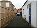
2
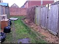
West Southbourne: electricity substation on footpath H08
Looking along this short public footpath which runs from Kimberley Road to a further footpath, H07, which is essentially a rear access driveway for houses in Kimberley Road and Paisley Road, the next parallel street. An electricity substation is on the right while some rubbish appears to have been fly-tipped on the left.
See Image for the view along the path behind us, and Image for the view towards us from ahead, with links to further photos along the mentioned routes.
Image: © Chris Downer
Taken: 8 Jan 2017
0.01 miles
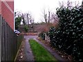
3
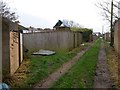
West Southbourne: footpaths H07 and H08 meet
This public footpath, H07, is essentially a rear access driveway for properties in Kimberley Road (to the left) and Paisley Road (right). To the left here is another little public footpath, number H08, linking with Kimberley Road.
See:
Image for the next view on path H07 ahead;
Image for the next view on path H07 behind us; and
Image for the next photo on path H08, left.
Each has links to further photos on the routes.
Image: © Chris Downer
Taken: 8 Jan 2017
0.01 miles
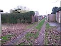
4

West Southbourne: graffiti and garden waste on footpath H07
This public footpath is essentially a rear access driveway for properties in Kimberley Road (to the right) and Paisley Road (left). The garage here has been daubed in graffiti and a large pile of tree cuttings has been deposited here also.
See Image for the next view on the path ahead, and Image for the next view behind us - each with links to further photos on the route.
Image: © Chris Downer
Taken: 8 Jan 2017
0.02 miles
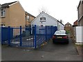
5
West Southbourne: unfenced premises on footpath H07
This public footpath is essentially a rear access driveway for properties in Kimberley Road (to the left) and Paisley Road (right). Most of the rear gardens have walls, fences or hedges but the one on the left here is an exception.
See Image for the next view on the path ahead, and Image for the next view behind us - each with links to further photos on the route.
Image: © Chris Downer
Taken: 8 Jan 2017
0.02 miles
6
West Southbourne: footpath H07 from Stourvale Road
This public footpath is essentially a rear access driveway for properties in Kimberley Road (to the left) and Paisley Road (right). We look along it here from its northwest end, on Stourvale Road.
See Image for the next view on the path, with links to further photos on the route.
Image: © Chris Downer
Taken: 8 Jan 2017
0.02 miles
7
West Southbourne: footpath H08 approaches Kimberley Road
Looking along this short public footpath which runs alongside a pre-school in Kimberley Road. It leads behind us to a further footpath, H07, which is essentially a rear access driveway for houses in Kimberley Road and Paisley Road, the next parallel street behind us.
See Image for the view up the path from the road ahead, and Image for the next photo on the path behind us, with links to further photos along the mentioned routes.
Image: © Chris Downer
Taken: 8 Jan 2017
0.02 miles
8
West Southbourne: footpath H07 reaches Stourvale Road
This public footpath is essentially a rear access driveway for properties in Kimberley Road (to the right) and Paisley Road (left). We look here along the northwest end of the path, as it emerges onto Stourvale Road with the railway line running along the embankment beyond.
See Image for the view along the path from the road ahead, and Image for the next view on the path behind us, with links to further photos on the mentioned routes.
Image: © Chris Downer
Taken: 8 Jan 2017
0.02 miles
9
West Southbourne: footpath H08 from Kimberley Road
Looking along this short public footpath which runs alongside a pre-school in Kimberley Road. It leads to a further footpath, H07, which is essentially a rear access driveway for houses in Kimberley Road and Paisley Road, the next parallel street.
See Image for the next photo on the path, with links to further photos along the mentioned routes.
Image: © Chris Downer
Taken: 8 Jan 2017
0.03 miles
10

West Southbourne: midway along footpath H07
This public footpath is essentially a rear access driveway for properties in Kimberley Road (to the left) and Paisley Road (right).
See Image for the next view on the path ahead, and Image for the next view behind us - each with links to further photos on the route.
Image: © Chris Downer
Taken: 8 Jan 2017
0.03 miles