1
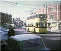
Bournemouth Corporation trolleybus 271 on Beresford Road ? 1969
On service 23 from Tuckton Bridge via Cranleigh Road, taken on the last day of normal trolleybus operation in Bournemouth.
This is one of a series of views featuring buses in the 60s, 70s, and 80s. http://www.geograph.org.uk/search.php?i=137652761
Image: © Alan Murray-Rust
Taken: 19 Apr 1969
0.02 miles
2
Shops in West Southbourne
The bus is emerging from Beresford Road; at this point, Seabourne Road (left) become Southbourne Grove.
Image: © Derek Harper
Taken: 10 Mar 2010
0.04 miles
3
Bournemouth trolleybus in West Southbourne
A 1962 Sunbeam MF2B trolleybus on route 21 to Christchurch via Tuckton. It is pictured in Southbourne Grove having come along Seabourne Road from Pokesdown. The feeder cable supplying electricity current to the overhead wiring can be seen at the top of the photo.
Image: © David Hillas
Taken: 5 Apr 1969
0.04 miles
4
Southbourne: the Malt & Hops
A pub which, apparently, ceased trading a few days ago. Certainly, it was closed now as I walked past it.
Image: © Chris Downer
Taken: 26 Dec 2008
0.05 miles
5
Southbourne, New Park Road
A suburban one-way road curving South from Southbourne Road back onto it.
Image: © Mike Faherty
Taken: 10 Aug 2014
0.05 miles
6
Road junction, West Southbourne
A somewhat complex junction of five roads, with Beresford Road arriving on the immediate right to meet Southbourne Road, which continues past a second mini-roundabout with Beaufort Road. Across on the right is New Park Road.
Image: © Derek Harper
Taken: 10 Mar 2010
0.05 miles
7
Seabourne Road, Pokesdown
Image: © Ian S
Taken: 15 Nov 2022
0.05 miles
8
Southbourne, The Malt & Hops
On the corner of Seabourne Road and Castlemain Avenue; closed 2009.
Image: © Mike Faherty
Taken: 14 Jul 2010
0.06 miles
9
The Brewhouse & Kitchen
Image: © JThomas
Taken: 21 Mar 2022
0.06 miles
10
Sign for the Brewhouse & Kitchen
Image: © JThomas
Taken: 21 Mar 2022
0.06 miles


