IMAGES TAKEN NEAR TO
Wick Lane, BOURNEMOUTH, BH6 4LF
Introduction
This page details the photographs taken nearby to Wick Lane, BH6 4LF by members of the Geograph project.
The Geograph project started in 2005 with the aim of publishing, organising and preserving representative images for every square kilometre of Great Britain, Ireland and the Isle of Man.

There are currently over 7.5m images from over14,400 individuals and you can help contribute to the project by visiting https://www.geograph.org.uk
Image Map (Loading...)


Getting Data...Please wait
Leaflet Map data © OpenStreetMap
Images are licensed for reuse under creativecommons.org/licenses/by-sa/2.0
Notes
- Clicking on the map will re-center to the selected point.
- The higher the marker number, the further away the image location is from the centre of the postcode.
Image Listing (96 Images Found)
Images are licensed for reuse under creativecommons.org/licenses/by-sa/2.0
Image
Details
Distance
1
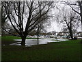
Tuckton: waterlogged riverside gardens
After a couple of weeks of persistent heavy rain, the River Stour (background) has burst its banks in a number of places and, here, the gardens are waterlogged.
Image: © Chris Downer
Taken: 4 Jan 2014
0.08 miles
2
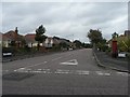
Southbourne: postbox № BH6 328, Riversdale Road
Riversdale Road, like its neighbours, comprises rather desirable bungalows, and it also has this Elizabeth II-reign postbox at its southern end.
Image: © Chris Downer
Taken: 6 Sep 2008
0.10 miles
3
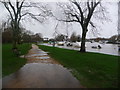
Tuckton: path alongside the swollen Stour
The riverside gardens at Tuckton are somewhat waterlogged, after a couple of weeks of persistent heavy rain; the Stour is also very much higher than usual and has caused flooding downstream in Christchurch and upstream at Iford.
The Tuckton Bridge can be seen in the distance.
Image: © Chris Downer
Taken: 4 Jan 2014
0.11 miles
4
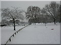
Tuckton, Riverlands
A park on the southern bank of the River Stour (to the left); normally a popular destination for walkers. An unusual scene in Bournemouth, after a night and morning of snowfall, with forecasts indicating that freezing temperatures will persist.
Image: © Mike Faherty
Taken: 2 Dec 2010
0.12 miles
5
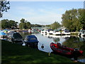
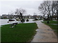
Wick, moorings
Moorings on the Stour; Tuckton Bridge in the distance.
Image: © Mike Faherty
Taken: 24 Sep 2009
0.13 miles
6

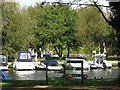
Pleasure Cruisers at Tuckton
These are the "Headland" boats that are used to take tourists on trips round Christchurch harbour. They date back to 1931 when the first of the class UNITY was built at the local boatyard of E F Elkins and sons which was located on land now occupied by waterside homes and known as Priory Quay. They have a beam of 8ft 9in and a length of 36 ft and are built of Oregon pine on oak frames and ribs. They have a deadweight of 5.5 tons and an unloaded draught of 10 inches. They have unusual propulsion in that the propeller is located in a tunnel in the aft section of the boat. The propeller is actual partially above the waterline and only a small part extends below the bottom of the boat. Water is sucked into the tunnel and expressed from the rear in the form of a simple water jet. This method of propulsion results in the bow dipping deeper into the water as speed increases. They have operated as pleasure boats every year since 1934 except for the war years. The boats are the Merry Widow (on the right) , Headland Queen, Headland Pal, Headland Belle and Headland Maid.
The waterside houses behind are on the north side of the river in Willow Way.
Image: © Nigel Mykura
Taken: 15 Nov 2011
0.13 miles
7
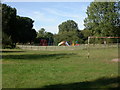
Wick, play area
On Riverlands, an open space between the River Stour and Wick Lane.
Image: © Mike Faherty
Taken: 24 Sep 2009
0.13 miles
8
Sign on the riverbank near Wick
The Stour Valley Way follows the riverbank here.
Image: © don cload
Taken: 17 Sep 2009
0.14 miles
9
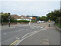
Wick Lane, Tuckton, near Christchurch
Wick Lane at Tuckton, near Christchurch. This road is on the route of National Cycle Network route 2.
Image: © Malc McDonald
Taken: 20 Aug 2021
0.14 miles
10
Tuckton: the riverside path enters the floodwater
The River Stour has risen considerably after a couple of weeks of persistent heavy rain. Here, the path through the Tuckton riverside gardens descends into flooded ground.
Image: © Chris Downer
Taken: 4 Jan 2014
0.15 miles