IMAGES TAKEN NEAR TO
Broadway, BOURNEMOUTH, BH6 4EE
Introduction
This page details the photographs taken nearby to Broadway, BH6 4EE by members of the Geograph project.
The Geograph project started in 2005 with the aim of publishing, organising and preserving representative images for every square kilometre of Great Britain, Ireland and the Isle of Man.

There are currently over 7.5m images from over14,400 individuals and you can help contribute to the project by visiting https://www.geograph.org.uk
Image Map
Images are licensed for reuse under creativecommons.org/licenses/by-sa/2.0
Notes
- Clicking on the map will re-center to the selected point.
- The higher the marker number, the further away the image location is from the centre of the postcode.
Image Listing (56 Images Found)
Images are licensed for reuse under creativecommons.org/licenses/by-sa/2.0
Image
Details
Distance
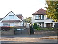
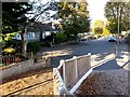
1
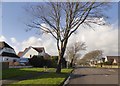
Broadway, Southbourne
Housing laid out with spacious roads and gardens
Image: © David Smith
Taken: 25 Jan 2018
0.05 miles
2
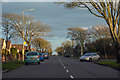
Bournemouth : Broadway
Looking along Broadway in Bournemouth.
Image: © Lewis Clarke
Taken: 27 Mar 2018
0.07 miles
3
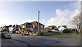
Junction of Nugent Road with Broadway, Southbourne
Image: © David Smith
Taken: 25 Jan 2018
0.09 miles
4
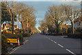
Bournemouth : Broadway
Looking along Broadway in Bournemouth.
Image: © Lewis Clarke
Taken: 27 Mar 2018
0.11 miles
5
Tuckton: footpath I13 from Sunnylands Avenue
This surprisingly narrow public footpath leads to the dead end of Southlands Avenue. See Image for the next view on the path ahead, with links to further photos along the route, and then along another path heading through to Belle Vue Road.
Meanwhile, see Image for the view to our left, with links photos along a continuing path through to Hengistbury Road.
Image: © Chris Downer
Taken: 22 Oct 2016
0.12 miles
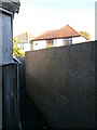
6
Tuckton: house wall abutting footpath I13
This surprisingly narrow public footpath leads from the dead end of Southlands Avenue (behind us) to Sunnylands Avenue, and here runs directly alongside a house built at the edge of its grounds, with no garden separating it.
See:
Image for the next view on the path behind us, with links to further photos along the route, and then along another path heading through to Belle Vue Road; and
Image for the view towards us from across the road, with links to photos on along a continuing path through to Hengistbury Road.
Image: © Chris Downer
Taken: 22 Oct 2016
0.12 miles
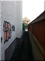
7
Tuckton: passing some graffiti on footpath I13
This surprisingly narrow public footpath leads from the dead end of Southlands Avenue (behind us) to Sunnylands Avenue, and here passes a graffitied wall as it completes the journey in that direction.
See:
Image for the next view on the path behind us, with links to further photos along the route, and then along another path heading through to Belle Vue Road; and
Image for the next photo ahead, with links to more photos along the route, and then along a continuing path through to Hengistbury Road.
Image: © Chris Downer
Taken: 22 Oct 2016
0.12 miles
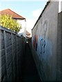
8
Tuckton: quick double-bend on footpath I13
This surprisingly narrow public footpath leads from the dead end of Southlands Avenue (behind us) to Sunnylands Avenue, and here has to do a quick left-right between the four abutting gardens.
See:
Image for the next view on the path behind us, with links to further photos along the route, and then along another path heading through to Belle Vue Road; and
Image for the next photo ahead, with links to more photos along the route, and then along a continuing path through to Hengistbury Road.
Image: © Chris Downer
Taken: 22 Oct 2016
0.13 miles
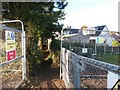
9
Tuckton: footpath I14 meets Sunnylands Avenue
This public footpath from Hengistbury Road arrives at the dead end of Sunnylands Avenue.
See Image for the next view on the path behind us, with links to further photos along the route.
See also Image for the view towards us from ahead, with links to photos along further paths heading through to Southlands Avenue and Belle Vue Road.
Image: © Chris Downer
Taken: 22 Oct 2016
0.14 miles
10
Tuckton: footpath I14 heads for Sunnylands Avenue
This public footpath from Hengistbury Road has crossed the grounds of St. Peter's School and now reaches the back gardens of Sunnylands Avenue, the road onto which it leads.
(The school is undergoing major building works, hence the fences; the school site is on the left and its playing fields on the right.)
See Image for the next view on the path behind us, and Image for the next view ahead - each with links to further photos along the route, and (ahead) continuing paths heading to Southlands Avenue and Belle Vue Road.
Image: © Chris Downer
Taken: 22 Oct 2016
0.14 miles