IMAGES TAKEN NEAR TO
Warren Edge Close, BOURNEMOUTH, BH6 4AY
Introduction
This page details the photographs taken nearby to Warren Edge Close, BH6 4AY by members of the Geograph project.
The Geograph project started in 2005 with the aim of publishing, organising and preserving representative images for every square kilometre of Great Britain, Ireland and the Isle of Man.

There are currently over 7.5m images from over14,400 individuals and you can help contribute to the project by visiting https://www.geograph.org.uk
Image Map
Images are licensed for reuse under creativecommons.org/licenses/by-sa/2.0
Notes
- Clicking on the map will re-center to the selected point.
- The higher the marker number, the further away the image location is from the centre of the postcode.
Image Listing (187 Images Found)
Images are licensed for reuse under creativecommons.org/licenses/by-sa/2.0
Image
Details
Distance
2
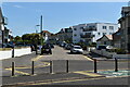
Clear Waters 1, designed to catch the sun in Southbourne
An apartment block fitted into the acute angle between two roads; completed in 2011-2012, when the penthouse sold for just over half a million pounds
Image: © David Smith
Taken: 25 Jan 2018
0.06 miles
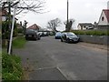
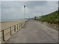
4
Southbourne, Warren Edge Path
Path from Southbourne Coast Road to Southbourne Promenade.
Image: © Mike Faherty
Taken: 27 May 2010
0.07 miles
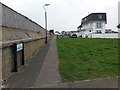
5
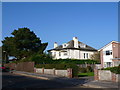
Admiralty Rd
This short road just behind the beach runs up from Church Rd to Ferry Rd. Most of this suburban area of Bournemouth is residential bungalows and detached houses.
Image: © Nigel Mykura
Taken: 15 Nov 2011
0.07 miles
7
Southbourne: extent of B.O.A.T. on Admiralty Road
Admiralty Road is a public right of way, number I07, designated as a Byway Open to All Traffic (or B.O.A.T.). This previously applied to the whole length of the road, but the road has been truncated now, some distance ahead, and the designation of the right of way truncated to about the point just ahead, according to recent mapping. This seems to coincide with the change in surface, from regular tarmacking with pavements beyond, compared with the rougher surface here.
See Image for the view towards us from the change in surface, and Image for the next view along the road ahead, with links to further photos along the road and former course.
Image: © Chris Downer
Taken: 11 Feb 2017
0.07 miles
8
Southbourne: northern half of Admiralty Road
Admiralty Road is a public right of way, number I07, designated as a Byway Open to All Traffic (or B.O.A.T.). This previously applied to the whole length of the road, but the road has been truncated now, some distance behind us, and the designation of the right of way truncated to about this point here, according to recent mapping. This seems to coincide with the change in surface, from regular tarmacking with pavements behind us, compared with the rougher surface ahead.
See Image for the next view on the road ahead, and Image for the next view along the road behind us, with links to further photos along the road and former course.
Image: © Chris Downer
Taken: 11 Feb 2017
0.08 miles
9
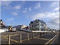
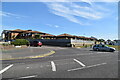
Southbourne Promenade
Beach huts and café on the right.
Image: © Mike Faherty
Taken: 27 May 2010
0.08 miles
10
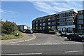
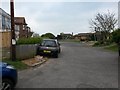
Southbourne: Ferry Road from its western end
This road appears to be like any other hereabouts, but it is designated as a public right of way - Byway Open to All Traffic (or B.O.A.T.) number I08. Large-scale mapping appears to specifically mark the route as the southern pavement, although because of the angle of the junction ahead, it is this northern pavement that extends the farther.
We are at the roadside of Warren Edge Road, just where it comes out on Southbourne Coast Road on our right.
See Image for the next view on the road ahead, with links to further photos along the route.
Image: © Chris Downer
Taken: 11 Feb 2017
0.08 miles