IMAGES TAKEN NEAR TO
Stourwood Avenue, BOURNEMOUTH, BH6 3QD
Introduction
This page details the photographs taken nearby to Stourwood Avenue, BH6 3QD by members of the Geograph project.
The Geograph project started in 2005 with the aim of publishing, organising and preserving representative images for every square kilometre of Great Britain, Ireland and the Isle of Man.

There are currently over 7.5m images from over14,400 individuals and you can help contribute to the project by visiting https://www.geograph.org.uk
Image Map
Images are licensed for reuse under creativecommons.org/licenses/by-sa/2.0
Notes
- Clicking on the map will re-center to the selected point.
- The higher the marker number, the further away the image location is from the centre of the postcode.
Image Listing (123 Images Found)
Images are licensed for reuse under creativecommons.org/licenses/by-sa/2.0
Image
Details
Distance
1
Southbourne, Sandcastle Nursery & Pre-School
On Stourcliffe Avenue: http://www.daynurseries.co.uk/daynursery.cfm/searchazref/50002022SANA
Image: © Mike Faherty
Taken: 21 Aug 2014
0.06 miles
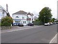
2
Southbourne, Norlington Care Ltd
Nursing & residential care home on Stourwood Avenue: http://norlington.co.uk/
Image: © Mike Faherty
Taken: 21 Aug 2014
0.07 miles
3
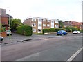
Southbourne, Stourwood Grange
Apartments on Stourwood Road.
Image: © Mike Faherty
Taken: 25 Aug 2014
0.08 miles
4
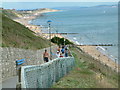
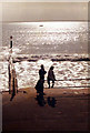
Southbourne Beach
This beach is situated between Bournemouth and Hengistbury Head.
Image: © Stuart Buchan
Taken: 12 Aug 2005
0.08 miles
5
Groynes on Southbourne Beach
Sea defences to slow down the movement of sand along the coast and to protect the beach from erosion. Aerial - http://maps.google.co.uk/?t=h&ll=50.721311,-1.81607&spn=0.006303,0.014248&t=h
Image: © Simon Johnston
Taken: 11 Jun 1984
0.08 miles
6
Southbourne, Blake Dene Court
Apartment block on Stourwood Road.
Image: © Mike Faherty
Taken: 25 Aug 2014
0.09 miles
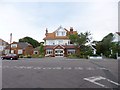
7
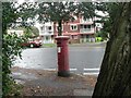
Southbourne: postbox № BH6 114, Southbourne Road
This Edward VII-reign postbox is right on the corner of Stourwood Road, where a large tree comes out of the pavement.
Image: © Chris Downer
Taken: 6 Sep 2008
0.09 miles
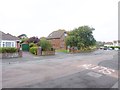
8
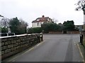
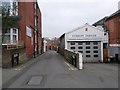
Southbourne: Carbery Lane reaches Stourwood Avenue
Carbery Lane is essentially a rear access driveway for the row of shops in Southbourne Road, and it also forms public footpath number H04 between Pine and Stourwood Avenues. The name Carbery refers to the fact that the row of shops is Carbery Row.
Here, we emerge onto Stourwood Avenue at the southeastern end of the Lane.
See Image for the view towards us from ahead, and Image for the next view on the Lane behind us, with links to further photos along the route.
Image: © Chris Downer
Taken: 11 Feb 2017
0.09 miles
9
Southbourne: Carbery Lane from Stourwood Avenue
Carbery Lane is essentially a rear access driveway for the row of shops in Southbourne Road, and it also forms public footpath number H04 between Pine and Stourwood Avenues. The name Carbery refers to the fact that the row of shops is Carbery Row.
Here, we look along the Lane from its southeast end, at Stourwood Avenue.
See Image for the next view on the Lane, with links to further photos along the route.
Image: © Chris Downer
Taken: 11 Feb 2017
0.10 miles
10
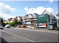
Southbourne, new builds
At the northern end of Pinecliffe Avenue.
Image: © Mike Faherty
Taken: 18 Aug 2014
0.10 miles