IMAGES TAKEN NEAR TO
Tuckton Road, BOURNEMOUTH, BH6 3JY
Introduction
This page details the photographs taken nearby to Tuckton Road, BH6 3JY by members of the Geograph project.
The Geograph project started in 2005 with the aim of publishing, organising and preserving representative images for every square kilometre of Great Britain, Ireland and the Isle of Man.

There are currently over 7.5m images from over14,400 individuals and you can help contribute to the project by visiting https://www.geograph.org.uk
Image Map (Loading...)


Getting Data...Please wait
Leaflet Map data © OpenStreetMap
Images are licensed for reuse under creativecommons.org/licenses/by-sa/2.0
Notes
- Clicking on the map will re-center to the selected point.
- The higher the marker number, the further away the image location is from the centre of the postcode.
Image Listing (114 Images Found)
Images are licensed for reuse under creativecommons.org/licenses/by-sa/2.0
Image
Details
Distance
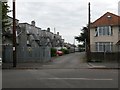
1

Tuckton: 116-134 Tuckton Road
Shops in Tuckton Road.
Image: © Chris Downer
Taken: 9 Mar 2008
0.01 miles
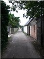
2
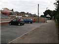
Tuckton: midway along footpath I19
This is the rear access driveway behind the main even-numbered shops in Tuckton Road, and the flats above them. The driveway also forms a public footpath, number I19, from Southlea Avenue (behind us) to Danesbury Avenue. The tarmac surface immediately behind us turns into gravel just here.
See Image for the view behind us from here, and Image for the next view on the path ahead - each with links to further photos along the route.
Image: © Chris Downer
Taken: 24 Sep 2016
0.02 miles
3
Tuckton: a westward view along footpath I19
This is the rear access driveway behind the main even-numbered shops in Tuckton Road, and the flats above them. The driveway also forms a public footpath, number I19, from Southlea Avenue (ahead) to Danesbury Avenue. The gravel surface becomes tarmac at the larger grey parade in the distance.
See Image for the next view on the path ahead, and Image for the next view behind - each with links to further photos along the route.
Image: © Chris Downer
Taken: 24 Sep 2016
0.02 miles
4
Tuckton: behind a parade of shops on Tuckton Road
This is the rear access driveway behind the main even-numbered shops in Tuckton Road, and the flats above them. The driveway also forms a public footpath, number I19, from Southlea Avenue (ahead) to Danesbury Avenue.
This segment is directly behind the more substantial parade of shops/flats towards the western end of the row.
See Image for the emergence onto the road ahead, and Image for the view behind us from here, and links to further photos along the route.
Image: © Chris Downer
Taken: 24 Sep 2016
0.02 miles
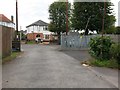
5
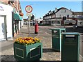
Tuckton: post office
Tuckton post office is at 165 Tuckton Road. The 13-ton weight limit indicated by the sign refers to Tuckton Bridge, which is left at the roundabout a little further on.
Image: © Chris Downer
Taken: 9 Mar 2008
0.03 miles
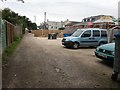
6
Tuckton: driveway behind Tuckton Road shops
Ahead of us is the rear access driveway behind the main even-numbered shops in Tuckton Road, and the flats above them.
The driveway also forms a public footpath, number I19, to Danesbury Avenue.
See Image for the view towards us from partway along the driveway, and links to further photos along the route.
Image: © Chris Downer
Taken: 24 Sep 2016
0.03 miles
7
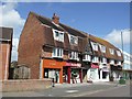
Row of Shops in Tuckton Road
Tuckton Road is Tuckton's High Street. This row of shops is in a building constructed in the first half of the 20th century.
Image: © mike smith
Taken: 13 Aug 2007
0.04 miles
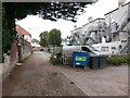
8
Tuckton: western end of footpath I19
This is the rear access driveway behind the main even-numbered shops in Tuckton Road, and the flats above them. The driveway also forms a public footpath, number I19, from Southlea Avenue (ahead) to Danesbury Avenue.
In the background is a grassy track which also used to be a public footpath: see Image
See Image for the view towards us from across the road, and Image for the next view on the driveway behind us, and links to further photos along the route.
Image: © Chris Downer
Taken: 24 Sep 2016
0.04 miles
9
Tuckton: eastern section of footpath I19
This is the rear access driveway behind the main even-numbered shops in Tuckton Road, and the flats above them. The driveway also forms a public footpath, number I19, from Southlea Avenue (ahead) to Danesbury Avenue.
See Image for the emergence onto Danesbury Avneue behind us, and Image for the next view on the path ahead, with links to further photos along the route.
Image: © Chris Downer
Taken: 24 Sep 2016
0.06 miles
10
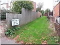
Tuckton: the end of former footpath I11
This grass track, running between the backs of houses in Horsa and Tuckton Roads, is marked as a public public footpath on current mapping, and indeed it once was. However, in recent years, the designation of public right of way must have been extinguished as it is no longer shown on the Borough Council's definitive map. I am sure the Ordnance Survey map will catch up soon.
An identical sign is displayed at the other end of the track - see Image - from where it can also be seen that a mound of earth or similar has been placed midway along, to thwart any attempt to go through.
Image: © Chris Downer
Taken: 24 Sep 2016
0.06 miles