IMAGES TAKEN NEAR TO
Twynham Road, BOURNEMOUTH, BH6 3EZ
Introduction
This page details the photographs taken nearby to Twynham Road, BH6 3EZ by members of the Geograph project.
The Geograph project started in 2005 with the aim of publishing, organising and preserving representative images for every square kilometre of Great Britain, Ireland and the Isle of Man.

There are currently over 7.5m images from over14,400 individuals and you can help contribute to the project by visiting https://www.geograph.org.uk
Image Map (Loading...)


Getting Data...Please wait
Leaflet Map data © OpenStreetMap
Images are licensed for reuse under creativecommons.org/licenses/by-sa/2.0
Notes
- Clicking on the map will re-center to the selected point.
- The higher the marker number, the further away the image location is from the centre of the postcode.
Image Listing (179 Images Found)
Images are licensed for reuse under creativecommons.org/licenses/by-sa/2.0
Image
Details
Distance

2
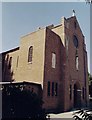
Our Lady Queen of Peace Roman Catholic Church, Southbourne
Erected in 1939.
Image: © Michael FORD
Taken: Unknown
0.03 miles
3
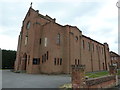
Our Lady Queen of Peace and Bless?d Margaret Pole, Southbourne: April 2013
Image: © Basher Eyre
Taken: 5 Apr 2013
0.03 miles
4
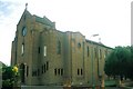
Southbourne: Catholic church of Our Lady Queen of Peace and Bless?d Margaret Pole
Image: © Chris Downer
Taken: Unknown
0.03 miles
5
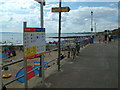
Warren Edge, Southbourne
A busy day at the beach,
Image: © Stuart Buchan
Taken: 12 Aug 2005
0.06 miles
6

Looking from Douglas Road into Wayside Road
Image: © Basher Eyre
Taken: 5 Apr 2013
0.06 miles
8
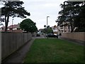
Southbourne: Twynham Road crosses Foxholes Road
There are three segments to Twynham Road - the short section further behind us, which is cut off at this end; the middle section, here, which is infilled with grass; and the main lengthy section ahead of us.
The middle section is designated as a public right of way - footpath I15 - specifically this southern pavement by the look of large-scale maps.
See Image for the view towards us from across the road, and Image for the next view on the path behind us, and links to further pictures along the public footpath.
Image: © Chris Downer
Taken: 24 Sep 2016
0.07 miles
9
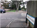
Southbourne: footpath I15 from across Foxholes Road
There are three segments to Twynham Road - the main lengthy section behind us; the middle section ahead, which is infilled with grass; and a farther short section beyond Belle Vue Road, which is cut off at the nearer end.
The middle grassed section is designated as a public right of way - footpath I15 - specifically the southern pavement by the look of large-scale maps.
See Image for the next view on the path ahead - looking back towards us - with links to further pictures along the public footpath.
Image: © Chris Downer
Taken: 24 Sep 2016
0.07 miles
10
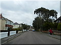
Twynham Road, Southbourne
Twynham Road is a minor residential road in Southbourne, in the eastern suburbs of Bournemouth.
Image: © Malc McDonald
Taken: 21 Jun 2022
0.08 miles