IMAGES TAKEN NEAR TO
Belle Vue Crescent, BOURNEMOUTH, BH6 3BW
Introduction
This page details the photographs taken nearby to Belle Vue Crescent, BH6 3BW by members of the Geograph project.
The Geograph project started in 2005 with the aim of publishing, organising and preserving representative images for every square kilometre of Great Britain, Ireland and the Isle of Man.

There are currently over 7.5m images from over14,400 individuals and you can help contribute to the project by visiting https://www.geograph.org.uk
Image Map
Images are licensed for reuse under creativecommons.org/licenses/by-sa/2.0
Notes
- Clicking on the map will re-center to the selected point.
- The higher the marker number, the further away the image location is from the centre of the postcode.
Image Listing (131 Images Found)
Images are licensed for reuse under creativecommons.org/licenses/by-sa/2.0
Image
Details
Distance
1
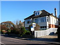
House in Foxholes Road
These 30's detached houses form a large part of Bournemouth's housing stock. The road used to be a main thoroughfare but developments over the years have turned it into a quiet residential road.
Image: © Nigel Mykura
Taken: 15 Nov 2011
0.03 miles
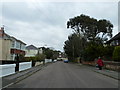
2
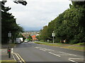
Belle Vue Road, Southbourne
Belle Vue Road in Southbourne, between Bournemouth and Christchurch.
Image: © Malc McDonald
Taken: 20 Aug 2021
0.05 miles
3
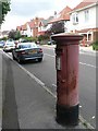
Tuckton: postbox № BH6 189, Guildhill Road
An Edward VII-reign specimen.
Image: © Chris Downer
Taken: 19 Jul 2008
0.05 miles
4
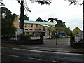
Southbourne: sports hall
At St. Peter’s Catholic Comprehensive School http://www.geograph.org.uk/photo/952921.
Image: © Chris Downer
Taken: 6 Sep 2008
0.08 miles
6
Southbourne: Twynham Road ? the grass road
One of the segments of Twynham Road has been closed to traffic and filled in with grass. In the distance, the road continues, in a motorable state, to St. Catherine's Road.
Image: © Chris Downer
Taken: 2 Feb 2008
0.10 miles
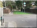
7
Tuckton: the grass segment of Twynham Road has been reconfigured
Eighteen months ago, the non-motorable segment of Tuckton Road, ahead, was all grassed over but with the two pavements remaining as if it were a normal road.
Since then, the road has been altered to incorporate a cycle route, with the tarmac surface going through the middle and grass to either side. The zebra crossing has also been reconfigured to allow a cycle crossing (see Image).
See Image for the previous view from roughly this spot.
Image: © Chris Downer
Taken: 7 Apr 2018
0.10 miles
8
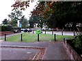
Southbourne: Twynham Road crosses Belle Vue Road
There are three segments to Twynham Road - the short section here, which is cut off at this end; the middle section, background, which is infilled with grass; and the main lengthy section beyond.
The middle section is designated as a public right of way - footpath I15 - specifically the southern pavement by the look of large-scale maps.
See Image for a closer view of the zebra crossing and links to further pictures along the public footpath.
Image: © Chris Downer
Taken: 24 Sep 2016
0.10 miles
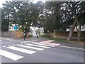
9
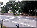
Southbourne: zebra crossing on Belle Vue Road
There are three segments to Twynham Road - the short section just behind us, which is cut off at this end; the middle section, ahead, which is infilled with grass; and the main lengthy section beyond.
The middle section is designated as a public right of way - footpath I15 - specifically the southern pavement by the look of large-scale maps.
See Image for a wider view from behind us, and Image for the view towards us from across the road - and links to further pictures along the public footpath.
UPDATE: Eighteen month later, the road has been altered, with a shared foot/cycle path through the middle and grass to either side - see Image
Image: © Chris Downer
Taken: 24 Sep 2016
0.10 miles
10

Looking from Douglas Road into Wayside Road
Image: © Basher Eyre
Taken: 5 Apr 2013
0.10 miles