IMAGES TAKEN NEAR TO
Belle Vue Road, BOURNEMOUTH, BH6 3BQ
Introduction
This page details the photographs taken nearby to Belle Vue Road, BH6 3BQ by members of the Geograph project.
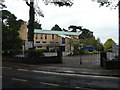
The Geograph project started in 2005 with the aim of publishing, organising and preserving representative images for every square kilometre of Great Britain, Ireland and the Isle of Man.

There are currently over 7.5m images from over14,400 individuals and you can help contribute to the project by visiting https://www.geograph.org.uk
Image Map
Images are licensed for reuse under creativecommons.org/licenses/by-sa/2.0
Notes
- Clicking on the map will re-center to the selected point.
- The higher the marker number, the further away the image location is from the centre of the postcode.
Image Listing (107 Images Found)
Images are licensed for reuse under creativecommons.org/licenses/by-sa/2.0
Image
Details
Distance
1
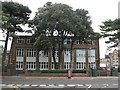
Southbourne: sports hall
At St. Peter’s Catholic Comprehensive School http://www.geograph.org.uk/photo/952921.
Image: © Chris Downer
Taken: 6 Sep 2008
0.03 miles
2
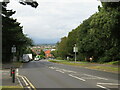
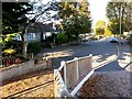
Belle Vue Road, Southbourne
Belle Vue Road in Southbourne, between Bournemouth and Christchurch.
Image: © Malc McDonald
Taken: 20 Aug 2021
0.05 miles
3
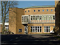
The De la Salle Theatre, St Peter's School
The well appointed De la Salle Theatre, at St Peter's Catholic Comprehensive School.
Image: © Peter Kazmierczak
Taken: 22 Apr 2010
0.05 miles
4
Southbourne: St. Peter?s Catholic Comprehensive School
A popular and well oversubscribed Catholic secondary school, St. Peter's covers the whole of Bournemouth plus Christchurch, Wimborne and parts of southern Hampshire as far afield as Lymington. It is on two sites, and this is the senior site, accommodating Years 9, 10 and 11 (age 13-16) and the sixth form.
Image: © Chris Downer
Taken: 6 Sep 2008
0.07 miles
5
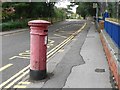
Southbourne: postbox № BH6 190, St. Catherine?s Road
This Edward VII-reign postbox, outside Image, could do with a lick of paint.
Image: © Chris Downer
Taken: 6 Sep 2008
0.07 miles
6
Tuckton: heading for Hengistbury Road on footpath I14
This public footpath heads towards Hengistbury Road from the dead end of Sunnylands Avenue, which is just behind us.
See Image for the next view on the path ahead, and Image for the next view behind us - each with links to further photos along the route, and (behind us) continuing paths heading to Southlands Avenue and Belle Vue Road.
Image: © Chris Downer
Taken: 22 Oct 2016
0.09 miles
7
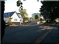
Tuckton: the dead end of Sunnylands Avenue
The dead end here abuts the grounds of St Peter's School, which has undergone expansion works over the summer which continue just now - it is one of the new buildings which we see in the background.
Meanwhile, heading left alongside the pictured house is a public footpath towards Hengistbury Road, crossing the school grounds to get there.
See Image for the next view on the path ahead, with links to further photos along the route.
See also Image for the view along another path, heading right just behind us - again with links to further photos along that route.
Image: © Chris Downer
Taken: 22 Oct 2016
0.09 miles
8
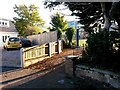
Tuckton: footpath I14 from Sunnylands Avenue
The dead end here abuts the grounds of St Peter's School, which has undergone expansion works over the summer which continue just now - it is one of the new buildings which we see in the background.
Meanwhile, swinging round to the left is a public footpath towards Hengistbury Road, crossing the school grounds to get there.
See Image for the next view on the path ahead, with links to further photos along the route.
See also Image for the view up the road to this point, with links to photos along further paths behind us heading through to Southlands Avenue and Belle Vue Road.
Image: © Chris Downer
Taken: 22 Oct 2016
0.09 miles
9
Tuckton: footpath I14 meets Sunnylands Avenue
This public footpath from Hengistbury Road arrives at the dead end of Sunnylands Avenue.
See Image for the next view on the path behind us, with links to further photos along the route.
See also Image for the view towards us from ahead, with links to photos along further paths heading through to Southlands Avenue and Belle Vue Road.
Image: © Chris Downer
Taken: 22 Oct 2016
0.09 miles
10
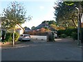
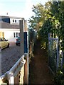
Tuckton: the dead end of Southlands Avenue
This short side-street ends abruptly with no widened turning circle.
Between the two driveways pictured runs a public footpath through to Sunnylands Avenue - see Image for the next view along the path, with links to further photos along the route, and a continuing path to Hengistbury Road.
Meanwhile, just behind us, another path heads towards Belle Vue Road - see Image
Image: © Chris Downer
Taken: 22 Oct 2016
0.10 miles