IMAGES TAKEN NEAR TO
Glen Road, BOURNEMOUTH, BH5 1NJ
Introduction
This page details the photographs taken nearby to Glen Road, BH5 1NJ by members of the Geograph project.
The Geograph project started in 2005 with the aim of publishing, organising and preserving representative images for every square kilometre of Great Britain, Ireland and the Isle of Man.

There are currently over 7.5m images from over14,400 individuals and you can help contribute to the project by visiting https://www.geograph.org.uk
Image Map
Images are licensed for reuse under creativecommons.org/licenses/by-sa/2.0
Notes
- Clicking on the map will re-center to the selected point.
- The higher the marker number, the further away the image location is from the centre of the postcode.
Image Listing (158 Images Found)
Images are licensed for reuse under creativecommons.org/licenses/by-sa/2.0
Image
Details
Distance
1
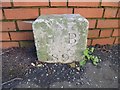
Old Boundary Marker by Watkin Road, Boscombe, Bournemouith
Municipal Boundary Marker by the UC road, in parish of Bournemouth (Bournemouth District), Watkin Road, Boscombe, next to corner of Percy Road in pavement against wall of "Camelot", East side of road.
Surveyed
Milestone Society Natroadional ID: HA_BM05pb
Image: © Milestone Society
Taken: Unknown
0.04 miles
2

Shalden Grange
My mum worked at this care home in Boscome during the 70s and 80s.
Image: © william
Taken: 16 Jun 2011
0.04 miles
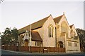
3
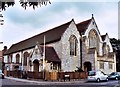
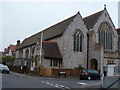
St Andrew, Boscombe
Listed building built in 1907.
Image: © Michael FORD
Taken: Unknown
0.04 miles
5
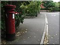
Boscombe: postbox № BH5 119, Wollstonecraft Road
An Edward VII-reign postbox in Wollstonecraft Road, which is named, like several roads in the area, after forenames of the Shelley family. Mary Shelley, creator of Frankenstein, wrote that and other works while living in Shelley Manor a short distance from here. Other such roads that spring to mind are Florence and Percy.
Image: © Chris Downer
Taken: 5 Jul 2008
0.06 miles
6
Boscombe, polling station
St. Andrew's Church Hall, Florence Road; Bournemouth East constituency.
Image: © Mike Faherty
Taken: 6 May 2010
0.06 miles
7

Westby Road, Boscombe
The western end of Westby Road is the last remaining dense bastion of bed & breakfasts in Boscombe. Nine can be seen here. As soon as larger establishments come up for sale, they are bought by developers who built expensive weekend flats.
Image: © Mike Faherty
Taken: 23 Oct 2008
0.11 miles
8

Boscombe, Shelley Manor Apartments
Recently completed, on Beechwood Road, next to Image http://www.shelleymanor.co.uk/
Image: © Mike Faherty
Taken: 14 Jul 2012
0.12 miles
9
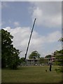
Boscombe, crane
On Beechwood Avenue, assisting with the construction of an apartment block next to Shelley Manor; as seen from Shelley Park. http://www.kinglifting.co.uk/
Image: © Mike Faherty
Taken: 27 May 2010
0.12 miles
10

Boscombe, closed road
Beechwood Road, closed for five days while a massive crane assists with the construction of an apartment block at Shelley Manor.
Image: © Mike Faherty
Taken: 27 May 2010
0.12 miles