IMAGES TAKEN NEAR TO
Surrey Road, BOURNEMOUTH, BH4 9HU
Introduction
This page details the photographs taken nearby to Surrey Road, BH4 9HU by members of the Geograph project.
The Geograph project started in 2005 with the aim of publishing, organising and preserving representative images for every square kilometre of Great Britain, Ireland and the Isle of Man.

There are currently over 7.5m images from over14,400 individuals and you can help contribute to the project by visiting https://www.geograph.org.uk
Image Map
Images are licensed for reuse under creativecommons.org/licenses/by-sa/2.0
Notes
- Clicking on the map will re-center to the selected point.
- The higher the marker number, the further away the image location is from the centre of the postcode.
Image Listing (154 Images Found)
Images are licensed for reuse under creativecommons.org/licenses/by-sa/2.0
Image
Details
Distance
1
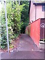
Westbourne: footpath A02 from Surrey Road
A footpath leading to the Upper Gardens - it descends some steps at the end of the flat stretch visible here: see Image
Image: © Chris Downer
Taken: 29 Jun 2016
0.08 miles
2
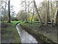
Bournemouth Gardens: stream among trees
The further upstream one goes in the Gardens, the less formal and more natural it feels. Here, we look upstream with the Image on the opposite side.
Image: © Chris Downer
Taken: 12 Jan 2008
0.08 miles
3
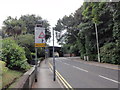
Defective road sign and railway bridge
Prince of Wales Road passing under the railway tracks which extend from Bournemouth Railway Depot.
Image: © Mat Tuck
Taken: 23 Jul 2013
0.08 miles
4
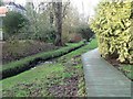
Bournemouth Gardens: elevated walkway
This section of the path alongside the Bourne Stream is an elevated wooden walkway.
Image: © Chris Downer
Taken: 12 Jan 2008
0.08 miles
5
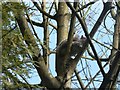
Bournemouth Gardens: camera-shy squirrel
The squirrels in the Gardens farther downstream, in the town centre, are usually pretty tame, sometimes even feeding out of children's hands. Perhaps here, a couple of miles upstream, in less formal gardens and with fewer passers-by, they are a little more suspicious of human interference. This one was doing its best to avoid my attention, characteristically moving round the tree trunk as he climbed and as I moved round.
Image: © Chris Downer
Taken: 12 Jan 2008
0.08 miles
6
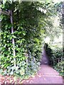
Westbourne: footpath A09 to the Upper Gardens
One of two public footpaths leading from this stretch of Surrey Road to the Upper Gardens. Unlike the other one (Image), this one is steps first and then flat.
See Image for a view up the steps towards us.
Image: © Chris Downer
Taken: 29 Jun 2016
0.08 miles
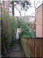
7
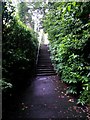
Westbourne: up the steps on footpath A09
The opposite view to Image] - the combination of thickly overhanging hedges and dreary dampness after a day of rain makes for a rather dark view.
The words NO CYCLING are helpfully painted on the tarmac facing those who have descended the steps.
The path leads behind us to the Upper Gardens - see Image] for a view along the path from that end.
Image: © Chris Downer
Taken: 29 Jun 2016
0.08 miles
8

Bournemouth Gardens: start of raised walkway
The start of one of the raised walkways in the Gardens, taking you through what would otherwise be rather squelchy underfoot.
Image: © Chris Downer
Taken: 27 Jan 2008
0.08 miles
9
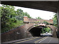
Railway bridge
Sidings extending from Bournemouth Railway Depot pass over this bridge, but the track is not a through route.
Image: © Mat Tuck
Taken: 23 Jul 2013
0.08 miles
10
Westbourne: view across the Gardens from footpath A02
This short public footpath leads down from Surrey Road, behind us, onto the Upper Gardens - one of several little paths doing the same thing along the two-mile length of the Gardens.
See Image for the full flight of steps from just behind us, and Image for the view towards us from the bottom.
Image: © Chris Downer
Taken: 18 Mar 2017
0.09 miles