IMAGES TAKEN NEAR TO
Crosby Road, BOURNEMOUTH, BH4 8JD
Introduction
This page details the photographs taken nearby to Crosby Road, BH4 8JD by members of the Geograph project.
The Geograph project started in 2005 with the aim of publishing, organising and preserving representative images for every square kilometre of Great Britain, Ireland and the Isle of Man.

There are currently over 7.5m images from over14,400 individuals and you can help contribute to the project by visiting https://www.geograph.org.uk
Image Map
Images are licensed for reuse under creativecommons.org/licenses/by-sa/2.0
Notes
- Clicking on the map will re-center to the selected point.
- The higher the marker number, the further away the image location is from the centre of the postcode.
Image Listing (160 Images Found)
Images are licensed for reuse under creativecommons.org/licenses/by-sa/2.0
Image
Details
Distance
1
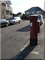
Westbourne: postbox № BH4 45, Crosby Road
A Victorian postbox, one of those built during the period 1879-1887 when the royal cipher was omitted.
Image: © Chris Downer
Taken: 20 Sep 2008
0.02 miles
2
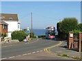
Alumhurst Road, Alum Chine, near Bournemouth
Alumhurst Road leads to Alum Chine, on Bournemouth's coastline. A double-deck bus has just made the steep climb from the bottom of the chine.
Visible in the distance are the cliffs at The Needles, at the western end of the Isle of Wight.
Image: © Malc McDonald
Taken: 21 Jun 2022
0.04 miles
3
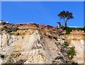
Cliff erosion Bournemouth Beach
The ends of the gardens are slowly but surely falling down into the sea. The structure is of Branksome sands overlayen by terrace gravels, both of which are soft and easily eroded.
Image: © Nigel Mykura
Taken: 15 Mar 2009
0.09 miles
4
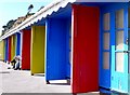
Primary Colour Beach Huts, Bournemouth
These huts are on the beach esplanade at the western end of Bournemouth close to the boundary with Poole.
Image: © Nigel Mykura
Taken: 15 Mar 2009
0.09 miles
5

Beach Huts, Bournemouth
These colourful huts are some of the many hundreds on Bournemouth sea front overlooking the beach.
Image: © Nigel Mykura
Taken: 15 Mar 2009
0.10 miles
6
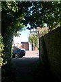
Westbourne: footpath A05 arrives at Sandbourne Road
This public footpath runs very close indeed to the boundary between Bournemouth and Poole - the brick wall on the right forms the boundary.
This segment is marked on Bournemouth Borough's definitive rights of way map as footpath A05, but it seems also to be marked as Poole footpath 63, which is what the sign refers to.
Behind us, the path turns left behind the back gardens of the houses, so it is indeed only this straight segment that is in Bournemouth.
See Image for a view along the path from the road ahead, and Image for the view behind us.
Image: © Chris Downer
Taken: 19 Jul 2016
0.10 miles
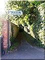
7
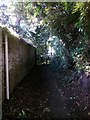
Westbourne: approaching the border on footpath A05
This public footpath runs very close indeed to the boundary between Bournemouth and Poole - the brick wall on the left forms the boundary.
This segment is marked on Bournemouth Borough's definitive rights of way map as footpath A05, but it also seems to be given as part of Poole footpath 63.
The path turns left behind the back gardens of the houses, a few yards ahead, so it is only this straight segment that is within Bournemouth - Poole path 63 continues down into Branksome Dene Chine.
See Image for a view along the path from the road ahead, and Image for the border being crossed ahead.
Image: © Chris Downer
Taken: 19 Jul 2016
0.10 miles
8
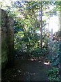
Westbourne: from Bournemouth into Poole on footpath A05
This public footpath runs very close indeed to the boundary between Bournemouth and Poole - the brick wall on the left forms the boundary.
This segment is marked on Bournemouth Borough's definitive rights of way map as footpath A05, but it also seems to be mapped as part of Poole footpath 63.
The path turns left here, to run behind the back gardens of the houses, while the boundary continues in a straight line. This is thus the crossing point from Bournemouth into Poole, and Poole path 63 continues into Branksome Dene Chine.
See Image for a view along the path from further behind us, and Image for the opposite view, from Poole into Bournemouth.
Image: © Chris Downer
Taken: 19 Jul 2016
0.10 miles
9
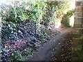
Westbourne: from Poole into Bournemouth on footpath 63
This public footpath runs very close indeed to the boundary between Bournemouth and Poole - the brick wall on the right forms the boundary.
The segment ahead is marked on Bournemouth Borough's definitive rights of way map as footpath A05, but it also seems to be mapped as part of Poole footpath 63, which is the continuing path behind us into Branksome Dene Chine.
Behind us, the path turns behind the back gardens of the houses, while the boundary continues in a straight course to the left - so we are looking from Poole into Bournemouth.
See Image for the opposite view across the border, and Image for the view along the path behind us.
Image: © Chris Downer
Taken: 19 Jul 2016
0.10 miles
10
Westbourne: footpath A05 has been usurped by Poole
This public footpath runs very close indeed to the boundary between Bournemouth and Poole - the brick wall on the left forms the boundary.
This segment is marked on Bournemouth Borough's definitive rights of way map as footpath A05, but it also seems to be shown as part of Poole footpath 63.
The path turns left behind the back gardens of the houses, so it is only this straight segment that is within Bournemouth.
See Image for a wider view of this part of Sandbourne Road, and Image or the next view along the path.
Image: © Chris Downer
Taken: 19 Jul 2016
0.10 miles