IMAGES TAKEN NEAR TO
Groveley Road, BOURNEMOUTH, BH4 8HF
Introduction
This page details the photographs taken nearby to Groveley Road, BH4 8HF by members of the Geograph project.
The Geograph project started in 2005 with the aim of publishing, organising and preserving representative images for every square kilometre of Great Britain, Ireland and the Isle of Man.

There are currently over 7.5m images from over14,400 individuals and you can help contribute to the project by visiting https://www.geograph.org.uk
Image Map
Images are licensed for reuse under creativecommons.org/licenses/by-sa/2.0
Notes
- Clicking on the map will re-center to the selected point.
- The higher the marker number, the further away the image location is from the centre of the postcode.
Image Listing (60 Images Found)
Images are licensed for reuse under creativecommons.org/licenses/by-sa/2.0
Image
Details
Distance
1

Westbourne: postbox № BH4 17, Alumhurst Road
A Victorian postbox on the corner of Warren Road.
Image: © Chris Downer
Taken: 20 Sep 2008
0.05 miles
2
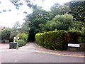
Westbourne: footpath A01 from Warren Road
Looking along this footpath which descends into the wooded idyll of Alum Chine from the end of Warren Road, with Drury Road off to the right.
See Image for the next view along the path, and links to further photos on the route.
Image: © Chris Downer
Taken: 14 Jul 2016
0.09 miles
3
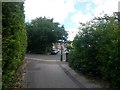
Westbourne: western end of footpath A01
This public footpath descends out of Alum Chine and emerges here at Warren Road (ahead) and Drury Road (left).
See Image for the view down the path from across the road, and Image for the next view down the path behind us, and links to further photos on the route.
Image: © Chris Downer
Taken: 14 Jul 2016
0.09 miles
4
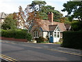
Westbourne, lodge
On Alumhurst Road, a lodge for Nightingale House, a mental health unit. The lodge has a sign "Bridges Nursery"; for growing plants, as a therapy.
Image: © Mike Faherty
Taken: 22 Sep 2009
0.09 miles
5
Westbourne: postbox № BH4 180, Westbourne Park Road
A George V-reign postbox on the corner of Herbert and Westbourne Park Roads.
Image: © Chris Downer
Taken: 20 Sep 2008
0.10 miles
6
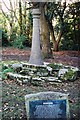
Westbourne: Skerryvore lighthouse replica
This little park is the site of a house called Skerryvore, in which Robert Louis Stevenson lived from 1885 to 1887. The house was destroyed in the war in 1940 and in 1957 Bournemouth Corporation built this – it is a replica of the lighthouse at Skerryvore, 12 miles southwest of the Isle of Tiree (56º19.4'N 7º6.9'W; approximate grid reference NL8426 Image), which Stevenson's (?)uncle, Alan Stevenson, built.
Stevenson wrote "Kidnapped" and "The Strange Case of Dr. Jekyll & Mr. Hyde" while here.
Image: © Chris Downer
Taken: Unknown
0.11 miles
7
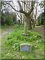
Skerryvore gardens and lighthouse replica
The site of the house where R L Stevenson stayed while writing some of his novels. It was named after the lighthouse built by his grandfather. The house was one of the few in the area to be hit by bombs in the second world war; the grounds are now a public park
Image: © David Smith
Taken: 30 Mar 2017
0.12 miles
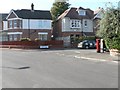
8

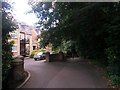
Rozel Manor, apartment block, Western Road
Image: © David Smith
Taken: 30 Mar 2017
0.12 miles
9
Westbourne: flats accessed off footpath A01
This public footpath leads into Alum Chine from Warren Road, and the first short stretch incorporates driveway access to the modern looking block of apartments on the left.
See Image for the next view along the path ahead, with links to further pictures on the route, and Image for the view behind us onto Warren Road.
Image: © Chris Downer
Taken: 14 Jul 2016
0.12 miles
10
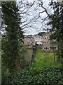
Alum Chine from Skerryvore gardens
Houses that back onto the slope of the chine
Image: © David Smith
Taken: 30 Mar 2017
0.12 miles