IMAGES TAKEN NEAR TO
East Avenue, BOURNEMOUTH, BH3 7BX
Introduction
This page details the photographs taken nearby to East Avenue, BH3 7BX by members of the Geograph project.
The Geograph project started in 2005 with the aim of publishing, organising and preserving representative images for every square kilometre of Great Britain, Ireland and the Isle of Man.

There are currently over 7.5m images from over14,400 individuals and you can help contribute to the project by visiting https://www.geograph.org.uk
Image Map
Images are licensed for reuse under creativecommons.org/licenses/by-sa/2.0
Notes
- Clicking on the map will re-center to the selected point.
- The higher the marker number, the further away the image location is from the centre of the postcode.
Image Listing (62 Images Found)
Images are licensed for reuse under creativecommons.org/licenses/by-sa/2.0
Image
Details
Distance
1
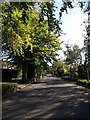
East Avenue
Image: © Derek Harper
Taken: 12 Oct 2009
0.02 miles
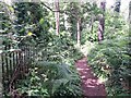
2
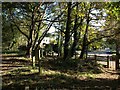
Talbot Woods: footpath A15 reaches East Avenue
This public footpath (left) is numbered by Bournemouth council although it is in the borough of Poole at this precise spot. It is seen here reaching the end of East Avenue, the wooden fence marking the borough boundary.
See Image for the view towards us from the road and Image for the next picture along the path behind us.
Image: © Chris Downer
Taken: 28 Jun 2016
0.05 miles
3
Talbot Woods: footpath A15 to Alyth Road
This is the very last road sign in Bournemouth, because the wooden fencing forms the boundary with Poole. Footpath A15 is numbered by Bournemouth despite immediately crossing the border - it does, however, hug the side garden wall which continues as the boundary and crosses back to reach Alyth Road.
See Image for the next picture along the path and links to further images along its route.
Image: © Chris Downer
Taken: 28 Jun 2016
0.05 miles
4
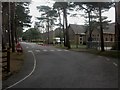
Bournemouth, Talbot Heath School
Independent CofE day & boarding school. For more information, see http://www.talbotheath.org.uk/
Image: © Mike Faherty
Taken: 22 Feb 2009
0.05 miles
5
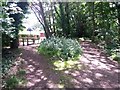
Talbot Woods: footpath A17 alongside Pug?s Hole
The public footpath from Rothesay Road heads towards the entrance to Image by firstly running alongside it for a short distance.
See Image for a view of the path as it reaches the entrance to the wood, and Image for the next view behind us, which is comparatively un-rural.
Image: © Chris Downer
Taken: 28 Jun 2016
0.05 miles
6
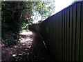
Talbot Woods: footpath A15 and the borough boundary
The fence alongside us is the end of a back garden in Bournemouth, and forms the Poole-Bournemouth boundary. This stretch of the footpath is therefore in Poole, although the boundary will leave the course of the fence in a few yards and run parallel but on the left-hand side of the path.
See Image for the next stretch of the footpath ahead of us, and Image for the next stretch behind.
Image: © Chris Downer
Taken: 28 Jun 2016
0.05 miles
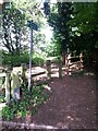
7
Talbot Woods: footpath A17 reaches Pug?s Hole
The public footpath from Rothesay Road reaches a gateless gateway (right) through which one accesses Image
See Image for a view of the path at the top of the bank ahead.
Image: © Chris Downer
Taken: 28 Jun 2016
0.05 miles
8
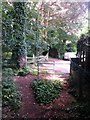
Talbot Woods: footpath A14 comes out on East Avenue
This footpath runs parallel with the Bournemouth borough boundary (a continuation of the course of the wooden fence, in both directions) and it is seen here as it arrives on the dead end of East Avenue. See Image] for a view towards us from the tarmac, and Image for the next view behind us.
Footpath A15 runs ahead to Alyth Road and is also numbered in Bournemouth, despite strutting across the border into Poole almost immediately. It does, though cross back. (See Image)
Image: © Chris Downer
Taken: 28 Jun 2016
0.05 miles
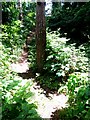
9
Edge of Talbot Heath
Footpath 111 reaches the edge of the heathland through open woodland, with access to East Avenue. See Image
Image: © Derek Harper
Taken: 12 Oct 2009
0.06 miles
10
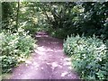
Talbot Woods: a stretch of footpath A15 in Poole
Public footpath A14 is numbered by Bournemouth Borough Council but a good proportion of it is actually in the borough of Poole - the back garden walls just behind the bushes on the right form the boundary.
See Image for the next stretch of path ahead, as it runs directly alongside the border, and Image] for the next stretch behind.
Image: © Chris Downer
Taken: 28 Jun 2016
0.06 miles