IMAGES TAKEN NEAR TO
Heathpoult Road, VERWOOD, BH31 7BN
Introduction
This page details the photographs taken nearby to Heathpoult Road, BH31 7BN by members of the Geograph project.
The Geograph project started in 2005 with the aim of publishing, organising and preserving representative images for every square kilometre of Great Britain, Ireland and the Isle of Man.

There are currently over 7.5m images from over14,400 individuals and you can help contribute to the project by visiting https://www.geograph.org.uk
Image Map (Loading...)


Getting Data...Please wait
Leaflet Map data © OpenStreetMap
Images are licensed for reuse under creativecommons.org/licenses/by-sa/2.0
Notes
- Clicking on the map will re-center to the selected point.
- The higher the marker number, the further away the image location is from the centre of the postcode.
Image Listing (18 Images Found)
Images are licensed for reuse under creativecommons.org/licenses/by-sa/2.0
Image
Details
Distance
1
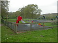
Eastworth Play Area
On Eastworth Road, owned by East Dorset District Council, & managed by Verwood Town Council. On the edge of housing development in Eastworth Road, overlooking countryside.
Image: © Mike Faherty
Taken: 18 Apr 2009
0.09 miles
4
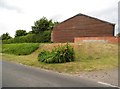
Eastworth Farmhouse
On Edmondsham Road; note the lead insurance plate above the right porch.
Image: © Mike Faherty
Taken: 18 Apr 2009
0.12 miles
5
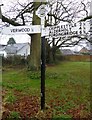
Old Direction Sign - Signpost by Edmondsham Road, Verwood Parish
Annulus & bar finial - 2 arms; Dorset halo with NGR by the UC road, in parish of Verwood (East Dorset District), Verwood, T-junction of Edmondsham Road and Eastworth Road, opposite Eastworth Farmhouse, on verge.
Surveyed
Milestone Society National ID: DO_SU0809.
Image: © Milestone Society
Taken: Unknown
0.13 miles
6
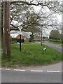
Eastworth, fingerpost
Traditional Dorset fingerpost, with halo, bar, place name & grid reference: "DORSET/VERWOOD EASTWORTH/084097". Although Eastworth Road, to the front, is no longer a through road, it is gratifying that Dorset CC has retained this post.
Image: © Mike Faherty
Taken: 18 Apr 2009
0.13 miles
7
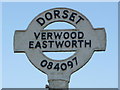
Verwood: detail of Eastworth finger-post
A close-up of the finial of the finger-post (see Image), giving location and grid reference details.
Image: © Chris Downer
Taken: 7 Mar 2010
0.13 miles
8
Eastworth, dismantled bridge
What appeared in Image to be a normal, albeit disused, bridge, has in fact been filled in; only the hump in the road and a concrete drain remain. http://history.verwood.org/verwood_station.htm
Image: © Mike Faherty
Taken: 18 Apr 2009
0.13 miles
9
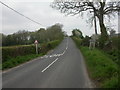
Eastworth, road bridge
Road bridge taking Edmondsham Road over the old Salisbury to Dorchester railway line http://history.verwood.org/verwood_station.htm , but not as it seems Image
Image: © Mike Faherty
Taken: 18 Apr 2009
0.13 miles
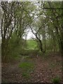
10
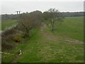
Eastworth, former railway line
Trackbed of the old Salisbury to Dorchester railway, closed 1964; as seen from Image http://history.verwood.org/verwood_station.htm
Image: © Mike Faherty
Taken: 18 Apr 2009
0.13 miles