IMAGES TAKEN NEAR TO
Church Hill, VERWOOD, BH31 6HT
Introduction
This page details the photographs taken nearby to Church Hill, BH31 6HT by members of the Geograph project.
The Geograph project started in 2005 with the aim of publishing, organising and preserving representative images for every square kilometre of Great Britain, Ireland and the Isle of Man.

There are currently over 7.5m images from over14,400 individuals and you can help contribute to the project by visiting https://www.geograph.org.uk
Image Map (Loading...)


Getting Data...Please wait
Leaflet Map data © OpenStreetMap
Images are licensed for reuse under creativecommons.org/licenses/by-sa/2.0
Notes
- Clicking on the map will re-center to the selected point.
- The higher the marker number, the further away the image location is from the centre of the postcode.
Image Listing (25 Images Found)
Images are licensed for reuse under creativecommons.org/licenses/by-sa/2.0
Image
Details
Distance
1
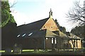
Verwood: parish church of St. Michael & All Angels
Only three UK towns begin with ‘V’. Two are Ventnor and Virginia Water; this is the parish church of the other, Verwood.
Image: © Chris Downer
Taken: Unknown
0.02 miles
4
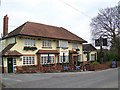
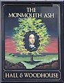
The Monmouth Ash, Verwood
The sign for the pub with its meaning Image
Image: © Maigheach-gheal
Taken: 29 Dec 2008
0.13 miles
5
Sign for the Monmouth Ash, Verwood
One of the romantic episodes associated with Verwood was the capture in 1685 of the Duke of Monmouth on Horton Heath, after the massacre at Sedgemoor .
The Duke of Monmouth, the Pretender to the Throne, landed at Lyme Regis with around 80 men on the 11th June 1685. It is reputed that one of the men was Daniel Defoe. The group marched north and collected more supporters on the way to Sedgmoor in Somerset. On the 6th July 1685 they met the forces of James II led by John Churchill (he later became the Duke of Marlborough).
Monmouth and his army were defeated and he fled to Dorset with 4 companions, one of which was Lord Grey. The plan was to head for Poole to find a boat to take them to Holland. At an Inn in Woodyates, tenanted by Robert Browning (ancestor of the future poet) and owned by the Earl of Shaftesbury the group got separated with Monmouth disguising himself as a shepherd and proceeding via Cranborne Chase towards Horton Heath, south of Verwood. An old woman, Amy Farrant, saw him climbing over a hedge near her cottage and reported him.
A search was organised early the next day and eventually a militiaman thought he saw a pile of old clothes beneath an Ash Tree in Slough Lane in Horton, in a ditch forming the boundary between Woodlands and Horton parishes. This spot is known to this day as 'Monmouth's Ash' and there is still an ash tree but it is probably not the same one.
The Duke was identified by his 'Order of the Garter badge' given to him by Charles II, his father. He was taken to Holt Lodge, and from there to Ringwood where he was kept for three days. He was taken away and beheaded on the 15th of July on Tower Hill. Over 300 of his supporters were executed at Judge Jeffrey's 'Bloody Assizes' after being tried in Dorchester.
There are many references to this event in the area, one of which is the naming of the 'Monmouth Ash' pub in Verwood.
Image: © Maigheach-gheal
Taken: 29 Dec 2008
0.14 miles
6
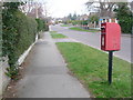
Verwood: postbox № BH31 193, Margards Lane
This postbox is on the northern junction of Hayward Crescent and is emptied at 4pm on weekdays and at 7 o'clock on Saturday mornings.
Image: © Chris Downer
Taken: 29 Mar 2009
0.19 miles
7
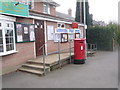
Verwood: post office and postbox № BH31 200
Verwood's post office is close to the main crossroads. The postbox is an Elizabeth II-reign, double-aperture box and it is emptied finally at 5:30pm on weekdays and at 11:30am on Saturdays. These are the latest collections of the town's fifteen postboxes.
Image: © Chris Downer
Taken: 29 Mar 2009
0.20 miles
10
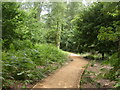
Verwood, Bugden's Copse
East of Verwood village, West of modern suburban housing, an oasis of tranquillity. According to an information board, the last vestige of Fayre Wood, from which Verwood derives its name. Once the source of wood for furniture and fuel, coppiced; now sympathetically managed. Local Nature Reserve & SSSI. http://195.49.180.81/index.jsp?articleid=330160
Image: © Mike Faherty
Taken: 20 Jun 2009
0.21 miles