
IMAGES TAKEN NEAR TO
St. Anthonys Road, BOURNEMOUTH, BH2 6PB
Introduction
This page details the photographs taken nearby to St. Anthonys Road, BH2 6PB by members of the Geograph project.
The Geograph project started in 2005 with the aim of publishing, organising and preserving representative images for every square kilometre of Great Britain, Ireland and the Isle of Man.

There are currently over 7.5m images from over14,400 individuals and you can help contribute to the project by visiting https://www.geograph.org.uk
Image Map
Images are licensed for reuse under creativecommons.org/licenses/by-sa/2.0
Notes
- Clicking on the map will re-center to the selected point.
- The higher the marker number, the further away the image location is from the centre of the postcode.
Image Listing (79 Images Found)
Images are licensed for reuse under creativecommons.org/licenses/by-sa/2.0
Image
Details
Distance
1
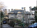
11, St Anthony's Road, Bournemouth
Suburban villa. c1910. In Arts and Crafts style having wooden-mullioned windows with leaded lights and casements, the ground-floor openings with hoods; oversailing eaves with exposed rafter ends; tall, swept-corniced stacks.
Image: © Mat Tuck
Taken: 18 Jan 2011
0.01 miles
2
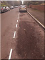
Bournemouth: pristine white lines on St. Anthony?s Road
This is one of the most prominent commuter parking streets, as it's one of the first streets outside the town centre to have unrestricted roadside parking. Town-centre workers have about a 10-minute walk from here.
The parking has not previously been marked with lines, but they have been painted this morning – my car, in front of us, is the first to be parked in this bay since the cones were removed a few minutes ago.
Perhaps they are being marked because there has been a problem with cars being parked overhanging the driveways.
The next bay behind us is just about to be painted – see Image
Image: © Chris Downer
Taken: 8 Mar 2019
0.03 miles
3
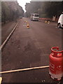
Bournemouth: painting parking lines on St. Anthony?s Road
This is one of the most prominent commuter parking streets, as it's one of the first streets outside the town centre to have unrestricted roadside parking. Town-centre workers have about a 10-minute walk from here.
The parking has not previously been marked with lines, but they are being painted this morning – the chalk dashes have been drawn as a painter's guide, and the wooden plank in front of us marks the end of this bay as there is a driveway on our left.
Perhaps they are being marked because there has been a problem with cars being parked overhanging the driveways.
The next bay behind us has just been finished – see Image
Image: © Chris Downer
Taken: 8 Mar 2019
0.06 miles
4
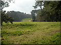
Meyrick Park, golf course
England's first municipal golf course, opened 1894. For more information, see http://www.theclubcompany.com/clubs/Meyrick-Park/golf-18-hole.html
Image: © Mike Faherty
Taken: 22 Feb 2009
0.10 miles
5
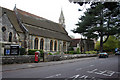
St Augustin's Church, Bournemouth
View from Wimborne Road end near the cemetery junction.
Image: © Kris
Taken: 6 May 2006
0.10 miles
6
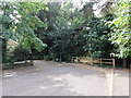
Dead end of St. Augustin's Road leading to Meyrick Park
Wood railings and gate prevents motorised access to Meyrick Park. Footpaths lead straight ahead and to the left once past the railings.
Image: © Mat Tuck
Taken: 23 Jul 2013
0.10 miles
7
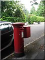
Bournemouth: postbox № BH2 150, St. Valerie Road
An Edward VII-reign postbox on a quiet back street of fairly desirable properties.
Image: © Chris Downer
Taken: 10 Jul 2008
0.11 miles
8
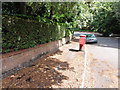
St. Valerie Road Post Box and OS Cut Mark
St. Valerie Road, Bournemouth. The wall on the left of the image has an Ordnance Survey Cut Mark.
Image: © Mat Tuck
Taken: 18 Aug 2013
0.11 miles
9
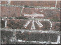
St. Valerie Road - OS Cut Mark
Detail image of the Ordnance Survey cut mark in St. Valerie Road, Bournemouth.
Image: © Mat Tuck
Taken: 18 Aug 2013
0.12 miles
10
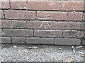
Bournemouth: benchmark in St. Valerie Road
An Ordnance Survey benchmark is carved inconspicuously in this wall, at a low level and at a seemingly random point midway along.
Image: © Chris Downer
Taken: 14 Jan 2019
0.12 miles