IMAGES TAKEN NEAR TO
Richmond Hill, BOURNEMOUTH, BH2 6HT
Introduction
This page details the photographs taken nearby to Richmond Hill, BH2 6HT by members of the Geograph project.
The Geograph project started in 2005 with the aim of publishing, organising and preserving representative images for every square kilometre of Great Britain, Ireland and the Isle of Man.

There are currently over 7.5m images from over14,400 individuals and you can help contribute to the project by visiting https://www.geograph.org.uk
Image Map
Images are licensed for reuse under creativecommons.org/licenses/by-sa/2.0
Notes
- Clicking on the map will re-center to the selected point.
- The higher the marker number, the further away the image location is from the centre of the postcode.
Image Listing (1505 Images Found)
Images are licensed for reuse under creativecommons.org/licenses/by-sa/2.0
Image
Details
Distance
1
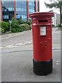
Bournemouth: postbox № BH2 12, Richmond Gardens
A fine, large, Victorian postbox just at the top of Richmond Hill. The office block in the background is Image
Image: © Chris Downer
Taken: 10 Jul 2008
0.01 miles
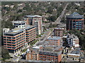
2
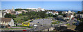
Bournemouth Town Centre area
This view from the carpark at The Mount, taken on a late afternoon in May, shows many of Bournemouth's town centre, distinctive landmarks. Close inspection reveals the white cliffs of the Needles Point which can just be detected just to the right of the large clifftop hotels.
On the horizon can be seen the two large blocks of white buildings which are the Bath Hill Court apartments. http://www.geograph.org.uk/photo/1929815
The spire of St. Peter's Church can be seen to the left and the thin, relatively modern style spire of Punshon Memorial Methodist Church in Exeter Road can be seen to the right of the picture.
Image: © Colin Vosper
Taken: 10 May 2011
0.01 miles
3
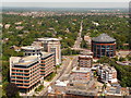
Bournemouth: Richmond Hill and Wimborne Road
Looking down from Image towards Richmond Hill, which is flanked by the office blocks Image on the left and Image to the right. For more discussion on Wimborne Road which disappears beyond, see Image
Image: © Chris Downer
Taken: 21 Jun 2010
0.02 miles
4
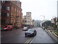
Bournemouth : Richmond Hill
Richmond Hill in Bournemouth, looking back down the hill from the top.
Image: © Lewis Clarke
Taken: 1 Oct 2007
0.02 miles
5
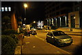
Bournemouth : Richmond Hill
A night scene of Richmond Hill which heads down into the town and has shops, flats and offices along it.
Image: © Lewis Clarke
Taken: 4 Oct 2010
0.02 miles
6
Richmond Hill
View from Bournemouth Balloon.
Image: © william
Taken: 23 Apr 2013
0.02 miles
7
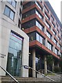
Bournemouth : Nationwide Bank on Richmond Hill
Nationwide Bank which dominates the skyline of Bournemouth,
Image: © Lewis Clarke
Taken: 1 Oct 2007
0.02 miles
8
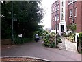
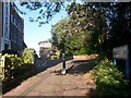
Bournemouth: top of Dalkeith Lane
Looking along the start of this public right of way - footpath C04 - from the dead end of Richmond Gardens. The path descends steeply (and, considering the urban location, with something of a rural feel) to meet Old Christchurch Road.
See Image for the view towards us from a little way down the path, and links to further photos on the route.
Mount Heatherbank is the rather attractive block of flats on the right.
Image: © Chris Downer
Taken: 15 Jun 2016
0.02 miles
9
Bournemouth: Dalkeith Lane reaches Richmond Gardens
Dalkeith Lane heads steeply up from Old Christchurch Road and emerges here at the dead end of Richmond Gardens, with the block of flats Mount Heatherbank on the left.
The lane is actually a path - public footpath no. C04 - rather than a lane in the usual sense of the word.
See Image for the view towards us, and Image for the next view on the path behind us, with links to further photos on the route.
Image: © Chris Downer
Taken: 13 Jan 2017
0.02 miles
10
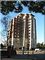
Bournemouth: Richmond Gate
A large 21st-century block of flats at the top of Richmond Hill.
Image: © Chris Downer
Taken: 11 Dec 2007
0.03 miles