IMAGES TAKEN NEAR TO
Branksome Wood Gardens, BOURNEMOUTH, BH2 6DD
Introduction
This page details the photographs taken nearby to Branksome Wood Gardens, BH2 6DD by members of the Geograph project.
The Geograph project started in 2005 with the aim of publishing, organising and preserving representative images for every square kilometre of Great Britain, Ireland and the Isle of Man.

There are currently over 7.5m images from over14,400 individuals and you can help contribute to the project by visiting https://www.geograph.org.uk
Image Map
Images are licensed for reuse under creativecommons.org/licenses/by-sa/2.0
Notes
- Clicking on the map will re-center to the selected point.
- The higher the marker number, the further away the image location is from the centre of the postcode.
Image Listing (139 Images Found)
Images are licensed for reuse under creativecommons.org/licenses/by-sa/2.0
Image
Details
Distance
1
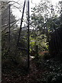
Bournemouth: private access to Kensington Drive from Meyrick Park
The notice on the fence stating "PRIVATE, No public right of way" has been put up in the last couple of months. A little further along, at the rear of the block of flats Baronsmede, there was a similar sign adding 'access to main road 80m' referring to this path.
That gave the impression that this was a publicly accessible route, which is not the case, and the Baronsmede sign has now been removed lest any confusion remain.
See Image for a view up to here from the other end of the path.
Image: © Chris Downer
Taken: 10 Jan 2019
0.02 miles
2
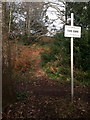
Bournemouth: warning sign on the edge of Meyrick Park
These signs are positioned at many access points to Meyrick Park, warning vigilance when crossing the golf course - i.e. to be aware of the possibility of low-flying golf balls.
This sign faces those arriving by way of Image, possibly the only such sign facing a non-public route. The waymarked path around the periphery of the park crosses the picture left-to-right just behind the sign.
Image: © Chris Downer
Taken: 10 Jan 2019
0.02 miles
3
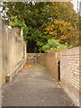
Bournemouth: private access to Meyrick Park from Kensington Drive
This is not a public right of way.
However, I had wandered up the small cul-de-sac a few weeks ago [October 2010] wondering if there was access to the golf course. Because the driveway up which we are looking has a small 'Private' sign on the wall off to our left, I had assumed that no public access was available.
But today I was walking through the golf course and noticed a private gate with a sign saying 'Access to main road 100 yards' and when I followed the periphery of the park to find the opening, this is where I came out.
However, I have received confirmation [October 2018] that there is no public right of way, so this is not therefore an official access to the park. The sign referred to above has been removed and one recently [January 2019] affixed to the fence at the top of the steps - see Image
Image: © Chris Downer
Taken: 4 Nov 2010
0.03 miles
4
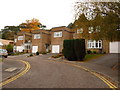
Bournemouth: Kensington Drive
A small cul-de-sac of desirable houses in the upmarket Meyrick Park area of town. Beyond the last one is the Image
Image: © Chris Downer
Taken: 4 Nov 2010
0.04 miles
5
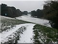
Bournemouth: sledging on Meyrick Park golf course
Looking down the fairway along the southern edge of Meyrick Park - the seventeenth, I think. A family enjoys the snow on this particularly steep segment of the course.
This at lunchtime, although the snow would fall more steadily this afternoon and the conditions for riding a sledge would have been even better!
Image: © Chris Downer
Taken: 1 Mar 2018
0.06 miles
6

Bournemouth: Leven Avenue
Needle debris from the multitude of pines in the Meyrick Park area are strewn across the pavements and gutters of Leven Avenue, a road of large upmarket houses in relatively large grounds.
Image: © Chris Downer
Taken: 4 Nov 2010
0.06 miles
7
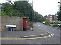
Bournemouth: postbox № BH2 26, Branksome Wood Road
A Victorian postbox to the west of the town centre. It looks as if the pavement has been resurfaced since the signs were installed!
Image: © Chris Downer
Taken: 4 Sep 2008
0.06 miles
8
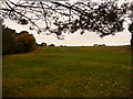
Bournemouth: steep bank on Meyrick Park golf course
Looking northwest along the southern edge of the golf course, up a substantial gradient.
Image: © Chris Downer
Taken: 4 Nov 2010
0.06 miles
9
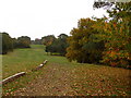
Bournemouth: southern edge of Meyrick Park
Looking back towards the clubhouse of Meyrick Park municipal golf course - I assume therefore that this is one of the last holes of the course.
Image: © Chris Downer
Taken: 4 Nov 2010
0.07 miles
10
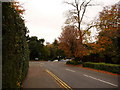
Bournemouth: bottom of Leven Avenue
A rush-hour cut-through in the upmarket Meyrick Park area reaches Branksome Wood Road. Queen's Road is diagonally opposite to the right and it is therefore not quite the crossroads that it seems from the map.
Image: © Chris Downer
Taken: 4 Nov 2010
0.08 miles