IMAGES TAKEN NEAR TO
The Triangle, BOURNEMOUTH, BH2 5RQ
Introduction
This page details the photographs taken nearby to The Triangle, BH2 5RQ by members of the Geograph project.
The Geograph project started in 2005 with the aim of publishing, organising and preserving representative images for every square kilometre of Great Britain, Ireland and the Isle of Man.

There are currently over 7.5m images from over14,400 individuals and you can help contribute to the project by visiting https://www.geograph.org.uk
Image Map
Images are licensed for reuse under creativecommons.org/licenses/by-sa/2.0
Notes
- Clicking on the map will re-center to the selected point.
- The higher the marker number, the further away the image location is from the centre of the postcode.
Image Listing (1131 Images Found)
Images are licensed for reuse under creativecommons.org/licenses/by-sa/2.0
Image
Details
Distance
1
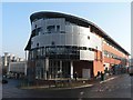
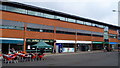
Bournemouth: central library
Bournemouth's distinctive state-of-the-art library was opened in 2002, and its design won the Prime Minister's Award for Better Public Buildings in 2003 (see http://www.betterpublicbuildings.gov.uk/finalists/2003/bournemouth/ ). It relocated from The College on the other side of town (see Image) where it had been since that building was built in 1919.
Image: © Chris Downer
Taken: 20 Dec 2007
0.01 miles
2
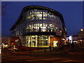
Bournemouth: central library at nightfall
A similar view to Image, looking end-on to the main entrance of the library building with The Triangle to the right and Avenue Road descending towards The Square on the left.
Image: © Chris Downer
Taken: 24 Nov 2010
0.01 miles
4
Bournemouth: Avenue Road and the library
Looking up Avenue Road, along the back of the Marks & Spencer store (extreme left), with the large glass of the Image reflecting the evening sunlight.
Image: © Chris Downer
Taken: 23 Mar 2012
0.01 miles
5
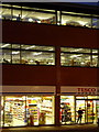
Bournemouth: nighttime detail of the library and Tesco Express
Looking towards the Image from the centre of The Triangle, with the Tesco Express one of the stores fronting onto The Triangle, below the two floors of the central library.
Image: © Chris Downer
Taken: 24 Nov 2010
0.02 miles
6
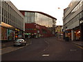
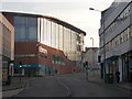
Bournemouth: Avenue Road heads for The Triangle
Looking up Avenue Road with the back of Marks & Spencer on the left and the multi-storey car park, incorporating retail units, on the right. The Image, prominent in the centre of the picture, fronts onto The Triangle just beyond.
Image: © Chris Downer
Taken: 1 Nov 2010
0.02 miles
7
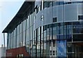
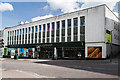
Bournemouth Central Library
The glass facade of the towns Library located at the triangle close to the centre of town.
Image: © Nigel Mykura
Taken: 4 Nov 2008
0.02 miles
8
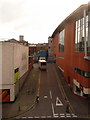
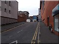
Bournemouth: Avenue Lane
Essentially a delivery access road for shops on the north side of Commercial Road, Avenue Lane goes up from Avenue Road with the Marks & Spencer store on the left, and the back end of the Image on the right.
Image: © Chris Downer
Taken: 9 Feb 2010
0.02 miles
9
Part of the Triangle, Bournemouth
New building is impressive, if a little featureless.
Image: © Jeremy Bolwell
Taken: 4 Sep 2014
0.02 miles
10
Marks & Spencer store - site of Bournemouth's first Quaker meeting house
The town's original Quaker meeting house stood here on part of the present site of the M&S store from 1882 until 1964, when it was given to Marks & Spencer in exchange for the present Quaker meeting house in Wharncliffe Road, Boscombe.
Image
Image: © Mike Searle
Taken: 11 Apr 2015
0.02 miles