IMAGES TAKEN NEAR TO
Avenue Lane, BOURNEMOUTH, BH2 5LS
Introduction
This page details the photographs taken nearby to Avenue Lane, BH2 5LS by members of the Geograph project.
The Geograph project started in 2005 with the aim of publishing, organising and preserving representative images for every square kilometre of Great Britain, Ireland and the Isle of Man.

There are currently over 7.5m images from over14,400 individuals and you can help contribute to the project by visiting https://www.geograph.org.uk
Image Map
Images are licensed for reuse under creativecommons.org/licenses/by-sa/2.0
Notes
- Clicking on the map will re-center to the selected point.
- The higher the marker number, the further away the image location is from the centre of the postcode.
Image Listing (1272 Images Found)
Images are licensed for reuse under creativecommons.org/licenses/by-sa/2.0
Image
Details
Distance
1
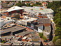
Bournemouth: looking down on Commercial and Avenue Roads
Similarly to Old Christchurch Road and Gervis Place to the east, Commercial and Avenue Roads head west from The Square in similar directions. Avenue Road (far right) still carries traffic while Commercial Road (diagonally through the picture) is pedestrianised as it also ascends to The Triangle.
Prominent features are the frontage of Image, towards bottom right; the roof of the award-winning central library (Image) and the top level of Image
Image: © Chris Downer
Taken: 21 Jun 2010
0.02 miles
2
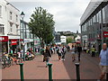
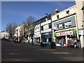
Bournemouth, Commercial Road
The eastern end of the road is pedestrianised, and one of Bournemouth's main shopping streets.
Image: © Mike Faherty
Taken: 16 Jul 2010
0.02 miles
3
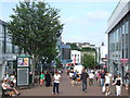
Commercial Road, Bournemouth
Commercial Road in the centre of Bournemouth is a pedestrianised shopping street.
Image: © Malc McDonald
Taken: 18 Aug 2012
0.02 miles
4
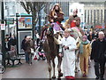
Bournemouth: camels ascend Commercial Road
Three wise men on camels make their way up the pedestrianised section of Commercial Road, to take part in the town's nativity parade which will commence shortly.
Image: © Chris Downer
Taken: 16 Dec 2012
0.02 miles
5
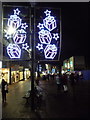
Bournemouth: Christmas lights in Commercial Road
Looking along Commercial Road, one of the main town-centre pedestrianised shopping streets, as it descends from The Triangle towards The Square. They are the same lights as have been used for at least the last four years: see Image
In the distance, on the right, we see the Primark store occupying the previous BHS store. The building this side of it has been demolished in recent weeks and can be seen in this picture taken in 2007: Image (The Currys shopfront is the one now demolished.)
Image: © Chris Downer
Taken: 17 Dec 2013
0.02 miles
6
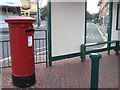
Bournemouth: postbox № BH2 31, Commercial Road
This postbox is at the top of the pedestrianised section of Commercial Road (see Image) at one of its two junctions with Image, which we see through the window of the bus shelter. Also through the bus shelter we see the wall of the award-winning Image
Image: © Chris Downer
Taken: 11 Sep 2008
0.02 miles
8
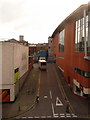
Bournemouth: Avenue Lane
Essentially a delivery access road for shops on the north side of Commercial Road, Avenue Lane goes up from Avenue Road with the Marks & Spencer store on the left, and the back end of the Image on the right.
Image: © Chris Downer
Taken: 9 Feb 2010
0.02 miles
9
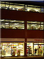
Bournemouth: nighttime detail of the library and Tesco Express
Looking towards the Image from the centre of The Triangle, with the Tesco Express one of the stores fronting onto The Triangle, below the two floors of the central library.
Image: © Chris Downer
Taken: 24 Nov 2010
0.02 miles
10

Commercial Road
Looking down the (pedestrianised) Commercial Road.
Image: © David Dixon
Taken: 6 Aug 2010
0.03 miles