IMAGES TAKEN NEAR TO
Beacon Road, BOURNEMOUTH, BH2 5DB
Introduction
This page details the photographs taken nearby to Beacon Road, BH2 5DB by members of the Geograph project.
The Geograph project started in 2005 with the aim of publishing, organising and preserving representative images for every square kilometre of Great Britain, Ireland and the Isle of Man.

There are currently over 7.5m images from over14,400 individuals and you can help contribute to the project by visiting https://www.geograph.org.uk
Image Map
Images are licensed for reuse under creativecommons.org/licenses/by-sa/2.0
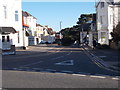
Notes
- Clicking on the map will re-center to the selected point.
- The higher the marker number, the further away the image location is from the centre of the postcode.
Image Listing (1126 Images Found)
Images are licensed for reuse under creativecommons.org/licenses/by-sa/2.0
Image
Details
Distance
2
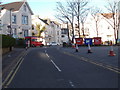
Eurostay Hotel, Beacon Road, Bournemouth
Image: © David Smith
Taken: 29 Mar 2017
0.01 miles
3
Priory Road - viewed from Beacon Road
Image: © Betty Longbottom
Taken: 18 Apr 2016
0.02 miles
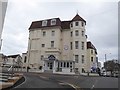
5

Bournemouth - Hotel Collingwood
The hotel on Priory Road was once a private house called "Rostrevor" and the former home of Sir Dan Godfrey (1868 - 1939), founder of the Bournemouth Symphony Orchestra. He lived here from 1922 - 1934.
Image
Image: © Mike Searle
Taken: 11 Apr 2015
0.02 miles
6
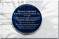
Bournemouth Blue Plaques: No. 28 - Sir Dan Godfrey
Sir Dan Godfrey was the founder of the Bournemouth Municipal Orchestra in 1893 (later the Bournemouth Symphony Orchestra), Britain's first permanent salaried municipal orchestra. The plaque is at the entrance front of the Hotel Collingwood in Priory Road, his former home during the 1920s and thirties when it was a private house known as "Rostrevor".
Image
Image
Image: © Mike Searle
Taken: 10 Apr 2015
0.02 miles
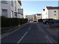
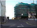
8
Bournemouth: Priory Road becomes West Cliff Road
Having ascended steeply from near the Pier Approach, Priory Road becomes West Cliff Road at the right-turn in the centre of the picture. West Cliff Road then runs for a mile or so towards Westbourne. This area is full of hotels and guest houses for all sizes of wallet.
Image: © Chris Downer
Taken: 16 Oct 2012
0.04 miles
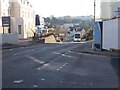
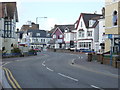
9
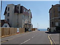
Bournemouth: Beacon Road heads into the sea
It doesn't, of course, but it almost looks like it from here. In fact, the road ahead ends at the clifftop after the short, steep descent ahead of us. The large, interestingly shaped building to the left is boarded up and will probably have the same fate as the bungalow at the edge of the picture - demolition for redevelopment as flats (going by the sign on the fence).
Image: © Chris Downer
Taken: 23 Jun 2014
0.05 miles