IMAGES TAKEN NEAR TO
Barton Wood Road, NEW MILTON, BH25 7NN
Introduction
This page details the photographs taken nearby to Barton Wood Road, BH25 7NN by members of the Geograph project.
The Geograph project started in 2005 with the aim of publishing, organising and preserving representative images for every square kilometre of Great Britain, Ireland and the Isle of Man.

There are currently over 7.5m images from over14,400 individuals and you can help contribute to the project by visiting https://www.geograph.org.uk
Image Map
Images are licensed for reuse under creativecommons.org/licenses/by-sa/2.0
Notes
- Clicking on the map will re-center to the selected point.
- The higher the marker number, the further away the image location is from the centre of the postcode.
Image Listing (44 Images Found)
Images are licensed for reuse under creativecommons.org/licenses/by-sa/2.0
Image
Details
Distance
1
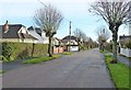
Seaward Avenue, Barton-on-Sea
This residential road forms a useful link between Sea Road and Barton Court Avenue.
Image: © mike smith
Taken: 2 Dec 2011
0.06 miles
2
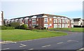
Pearce-Smith Court, Barton-on-Sea
Although this block does not have balconies, the pointed window arrangements provide 180 degree views to those living at the front of the flats.
Image: © mike smith
Taken: 2 Dec 2011
0.09 miles
3
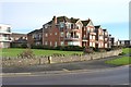
Barton House, Barton-on-Sea
There are many fairly new apartment blocks on the sea-front at Barton. Most, like this one has balconies, giving wonderful views over the Solent.
Image: © mike smith
Taken: 2 Dec 2011
0.11 miles
4
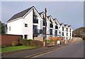
New Dwellings on Sea Road, Barton-on-Sea
The new homes are just being completed, and are at the southern end of Sea Road. As can be seen, the balconies are angled to provide sea views for the occupants.
Image: © mike smith
Taken: 2 Dec 2011
0.12 miles
5
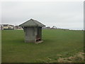
Barton on Sea, shelter
Rather forlorn looking shelter on the grass between Marine Drive & the cliff edge. For how much longer will it be there? The cliff top is eroding steadily. For a comprehensive account, see Ian West's website http://www.soton.ac.uk/~imw/Barton-Erosion-History.htm
Image: © Mike Faherty
Taken: 22 Dec 2008
0.13 miles
6
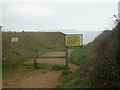
Barton on Sea, path closure
Sign warning that the path in front is closed because of the danger of cliff erosion. Local dog walkers seem content to ignore it, as it's been happening for centuries. For a detailed explanation, see http://www.soton.ac.uk/~imw/Barton-Erosion-History.htm
Image: © Mike Faherty
Taken: 22 Dec 2008
0.14 miles
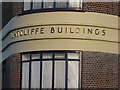
7

?Westcliffe? very close-up
Close detail of the wording of Westcliffe Buildings (Image), showing the cornery 'typeface' used.
Image: © Chris Downer
Taken: 30 Jul 2007
0.14 miles
8
?Westcliffe Buildings? close-up
Detail of the art deco shops: Image
Image: © Chris Downer
Taken: 30 Jul 2007
0.14 miles
9
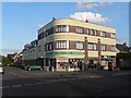
Barton on Sea: art deco row of shops
This row of shops is Westcliffe Buildings, on the corner of Sea Road and Seaward Avenue.
Image: © Chris Downer
Taken: 30 Jul 2007
0.14 miles
10
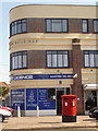
Barton on Sea: postbox № BH25 129, Sea Road
This postbox stands outside Westcliffe Buildings (see Image), one of whose shops is Sea Road Post Office. The postbox is emptied finally at 5:15 on weekday evenings and at 12:15 on Saturday afternoons.
Image: © Chris Downer
Taken: 13 Apr 2009
0.14 miles