IMAGES TAKEN NEAR TO
Doe Copse Way, NEW MILTON, BH25 5GN
Introduction
This page details the photographs taken nearby to Doe Copse Way, BH25 5GN by members of the Geograph project.
The Geograph project started in 2005 with the aim of publishing, organising and preserving representative images for every square kilometre of Great Britain, Ireland and the Isle of Man.

There are currently over 7.5m images from over14,400 individuals and you can help contribute to the project by visiting https://www.geograph.org.uk
Image Map
Images are licensed for reuse under creativecommons.org/licenses/by-sa/2.0
Notes
- Clicking on the map will re-center to the selected point.
- The higher the marker number, the further away the image location is from the centre of the postcode.
Image Listing (17 Images Found)
Images are licensed for reuse under creativecommons.org/licenses/by-sa/2.0
Image
Details
Distance
1
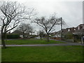
New Milton, Hazelwood Avenue
Like so many coastal towns in the south, bungalows are a popular choice for housing. Hazelwood Avenue, as seen from junction with Beechwood Avenue.
Image: © Mike Faherty
Taken: 20 Dec 2008
0.07 miles
2
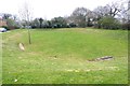
Sunken Green
This is in a newish housing development. No doubt it is used as a play area by local children, but the sunken aspect suggests it doubles as a flood-avoidance drainage system.
Image: © mike smith
Taken: 5 Apr 2012
0.08 miles
3

Velvet Lawn Road
Very attractive name for this road in a development to the north of New Milton.
Image: © mike smith
Taken: 5 Apr 2012
0.10 miles
4
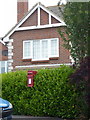
New Milton: postbox № BH25 196, Velvet Lawn Road
This small postbox serves a modern housing estate and is emptied finally at 4:30pm on weekdays and at noon on Saturdays.
Image: © Chris Downer
Taken: 11 Jun 2011
0.10 miles
5

Footpath near Stem Lane
This path leads from Antler Drive to Beechwood Avenue, although towards the latter it is a proper tarmac path. It is named Dark Lane on my street atlas, but such a title is not given at either end of the actual path.
Image: © mike smith
Taken: 5 Apr 2012
0.10 miles
6
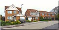
Typical Houses on Antler Drive
This development was constructed in the 1990s.
Image: © mike smith
Taken: 5 Apr 2012
0.17 miles
7
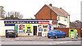
Convenience Store on Beechwood Avenue
This corner shop includes a post office in addition to the alcohol and general groceries on offer.
Image: © mike smith
Taken: 5 Apr 2012
0.18 miles
8
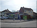
New Milton: Beechwood Avenue Post Office
A McColl's-branded convenience store serving the northern suburb of New Milton, incorporating Beechwood Avenue Post Office. Marley Avenue is the side road to the left.
Image: © Chris Downer
Taken: 25 Mar 2012
0.18 miles
9
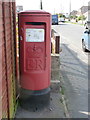
New Milton: postbox № BH25 192, Beechwood Avenue
This 'Type K' postbox - a design from the very late 1970s - stands alongside the forecourt of Image
Image: © Chris Downer
Taken: 25 Mar 2012
0.18 miles
10

Stem Lane (Old and New)
The original Stem Lane was on the right in the photo, and is now a footpath. The new Stem Lane (left) was a realignment and widening about 25 years ago when new housing was being developed to the east of the road.
Image: © mike smith
Taken: 5 Apr 2012
0.19 miles