IMAGES TAKEN NEAR TO
Holmsley, RINGWOOD, BH24 4HY
Introduction
This page details the photographs taken nearby to Holmsley, BH24 4HY by members of the Geograph project.
The Geograph project started in 2005 with the aim of publishing, organising and preserving representative images for every square kilometre of Great Britain, Ireland and the Isle of Man.

There are currently over 7.5m images from over14,400 individuals and you can help contribute to the project by visiting https://www.geograph.org.uk
Image Map
Images are licensed for reuse under creativecommons.org/licenses/by-sa/2.0
Notes
- Clicking on the map will re-center to the selected point.
- The higher the marker number, the further away the image location is from the centre of the postcode.
Image Listing (27 Images Found)
Images are licensed for reuse under creativecommons.org/licenses/by-sa/2.0
Image
Details
Distance
1
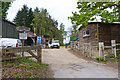
Holmsley Timber Mill
This sawmill is in the heart of the New Forest, adjacent to Holmsley Inclosure. It is the home of Oak Craft wooden buildings.
Image: © mike smith
Taken: 27 Apr 2011
0.03 miles
2
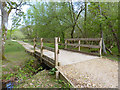
Bridges over Streams in Holmsley Inclosure
There are three parallel streams/ditches crossing the trackway here, with three wooden bridges spanning them. The handrails of the two further back can just be discerned on the right of the track.
Image: © mike smith
Taken: 27 Apr 2011
0.09 miles
4
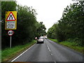
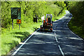
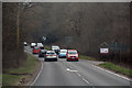
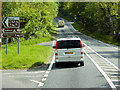
A35 View
Looking along the A35 in the New Forest, Hampshire.
Image: © Gordon Griffiths
Taken: 10 Sep 2021
0.13 miles
5
New Forest : The A35
Looking along the A35 in the New Forest.
Image: © Lewis Clarke
Taken: 25 Mar 2018
0.14 miles
6
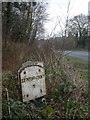
Holmsley, milepost
Milepost on the A35 just south of Holmsley Mill. Concrete post (unusual), triangular plan, with two metal plates attached. The other side reads "Xt. CHURCH/7/BOURNE/12"; note the abbreviations for Christchurch & Bournemouth. Probably mid-C19 plates; post might be later.
Image: © Mike Faherty
Taken: 29 Jan 2009
0.14 miles
7
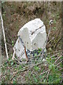
Old Milepost by the A35, Holmsley
The remains of metal plates attached to concrete post by the A35, in parish of BURLEY (NEW FOREST District), Brownhill Enclosure; 300m North of Holmsley Toll house, by the road, on West side of road. Lyndhurst plate, erected by the Christchurch & Lyndhurst Turnpike Trust in the 19th century.
The damage was caused by recent careless verge cutting.
Inscription reads:-
: LYNDHURST / 7 / (XT CHURCH / 7 / BOURNE / 12) :
Milestone Society National ID: HA_LHCC07.
Image: © Milestone Society
Taken: 13 Apr 2017
0.15 miles
8
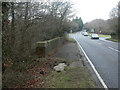
Holmsley, Avon Water bridge
Bridge on the A35 carrying traffic over Avon Water Image, which rises south of Burley & flows into the sea at Keyhaven.
Image: © Mike Faherty
Taken: 29 Jan 2009
0.15 miles
10
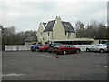
Holmsley Tea Rooms
Once railway station, now tea room & restaurant. On the Brockenhurst to Ringwood line, opened 1847, closed 1967. For a picture of the station in 1964, see http://www.subbrit.org.uk/sb-sites/stations/h/holmsley/index.shtml
Image: © Mike Faherty
Taken: 29 Jan 2009
0.19 miles