IMAGES TAKEN NEAR TO
Wayside Road, RINGWOOD, BH24 2SH
Introduction
This page details the photographs taken nearby to Wayside Road, BH24 2SH by members of the Geograph project.
The Geograph project started in 2005 with the aim of publishing, organising and preserving representative images for every square kilometre of Great Britain, Ireland and the Isle of Man.

There are currently over 7.5m images from over14,400 individuals and you can help contribute to the project by visiting https://www.geograph.org.uk
Image Map
Images are licensed for reuse under creativecommons.org/licenses/by-sa/2.0
Notes
- Clicking on the map will re-center to the selected point.
- The higher the marker number, the further away the image location is from the centre of the postcode.
Image Listing (14 Images Found)
Images are licensed for reuse under creativecommons.org/licenses/by-sa/2.0
Image
Details
Distance
1
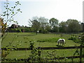
St. Leonards, horse grazing
At a property on Grange Estate, seen from the footpath to Wayside Road.
Image: © Mike Faherty
Taken: 17 Apr 2011
0.10 miles
2
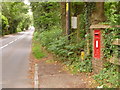
St. Leonards: postbox № BH24 32, Boundary Lane
A cyclist has just ridden, towards Matchams or Ringwood, past this Elizabeth II-reign postbox which is set into its own brick pillar and is emptied each morning, except Sunday, at 9 o'clock.
Image: © Chris Downer
Taken: 8 Jun 2009
0.14 miles
3
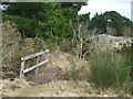
Footbridge in Hurn Forest
The footpath leads from Hurn Forest, to Boundary Lane.
Image: © Lorraine and Keith Bowdler
Taken: 24 Feb 2010
0.17 miles
4
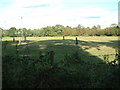
Farmland, St. Leonards
There is mixed use of the land in this area. Farmland is shown, there is also housing and a couple of campsites.
Image: © Stuart Buchan
Taken: 9 Oct 2005
0.17 miles
5
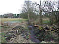
Stream on the edge of Hurn Forest
Image: © Lorraine and Keith Bowdler
Taken: 24 Feb 2010
0.17 miles
6
Hurn Forest, footbridge
Over a ditch at the start of the footpath from Hurn Forest to Wayside Road and Boundary Lane.
Image: © Mike Faherty
Taken: 17 Apr 2011
0.18 miles
7
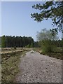
Hurn Forest, forestry track
From the north-eastern margin of the plantation into its depths.
Image: © Mike Faherty
Taken: 17 Apr 2011
0.20 miles
8
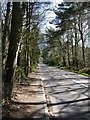
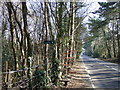
St. Leonards, Boundary Lane
From Ringwood Road to Hurn Road; tree-lined at this end, passing detached cottages and houses, horse grazings, nurseries and camp sites.
Image: © Mike Faherty
Taken: 7 Apr 2011
0.20 miles
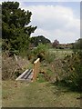
9
Footpath off Boundary Lane, St Leonards
The path sign-posted to the A31 goes over 3 stiles and through 3 gates along its 800m length.
Image: © Lorraine and Keith Bowdler
Taken: 5 Mar 2010
0.21 miles
10
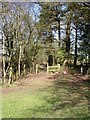
St. Leonards, stile
On the footpath from Boundary Lane to Ringwood Road.
Image: © Mike Faherty
Taken: 7 Apr 2011
0.23 miles