IMAGES TAKEN NEAR TO
Addison Square, RINGWOOD, BH24 1NY
Introduction
This page details the photographs taken nearby to Addison Square, BH24 1NY by members of the Geograph project.
The Geograph project started in 2005 with the aim of publishing, organising and preserving representative images for every square kilometre of Great Britain, Ireland and the Isle of Man.

There are currently over 7.5m images from over14,400 individuals and you can help contribute to the project by visiting https://www.geograph.org.uk
Image Map
Images are licensed for reuse under creativecommons.org/licenses/by-sa/2.0
Notes
- Clicking on the map will re-center to the selected point.
- The higher the marker number, the further away the image location is from the centre of the postcode.
Image Listing (14 Images Found)
Images are licensed for reuse under creativecommons.org/licenses/by-sa/2.0
Image
Details
Distance
1
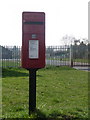
Ringwood: postbox № BH24 55, Parsonage Barn Lane
This little postbox is emptied finally at 5:15 on weekday evenings and at 11:45 on Saturday mornings.
Image: © Chris Downer
Taken: 20 Mar 2011
0.11 miles
2
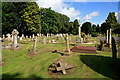
Ringwood Cemetery, Hightown Road
The cemetery is operated by Ringwood Town Council and is quite large. It has consecrated and unconsecrated areas, plus an area for "other denominations".
Image: © Peter Facey
Taken: 23 May 2006
0.11 miles
3
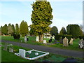
Ringwood Cemetery
On Hightown Road: http://www.ringwood.gov.uk/Your_Council/Cemetery-Information/Interment-Fees.html
Image: © Mike Faherty
Taken: 20 Nov 2011
0.13 miles
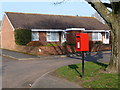
4
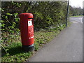
Ringwood: postbox № BH24 30, Castleman Way
This 'Type K' postbox (introduced in 1980) is emptied finally at 5:30pm on weekdays and at 12:45pm on Saturdays.
Image: © Chris Downer
Taken: 20 Mar 2011
0.14 miles
5
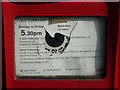
Ringwood: damaged postbox information plate
Detail of the collection plate on Image The ring of numbers would originally have indicated which collection was next, in the days when collection times throughout the day were advertised. The postman could advance the dial by one when he emptied the box; the relevant figure would show through a circular hole in the display. Nowadays, only the final collection time is given and the replacement information display, which is starting to peel off badly, covered the previous hole.
Image: © Chris Downer
Taken: 20 Mar 2011
0.14 miles
6
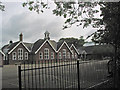
Ringwood Junior School
The school is in Hightown Road.
Image: © Peter Facey
Taken: 28 May 2006
0.15 miles
7
Ringwood: postbox № BH24 71, Kingsfield
This small postbox is emptied finally at 4pm on weekdays and at 11:45am on Saturdays.
Image: © Chris Downer
Taken: 20 Mar 2011
0.15 miles
8
Ringwood Junior School
On Hightown Road: http://www.ringwood-junior.hants.sch.uk/intro.htm
Image: © Mike Faherty
Taken: 20 Nov 2011
0.17 miles
9
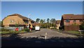
Waterloo Way, Ringwood
Seen from Image The housing estate is very close to the site of Ringwood station, and the three closes leading off from Waterloo Way also bear
the name of a London rail terminus: Victoria Gardens, Charing Close and Euston Grove.
Image: © Derek Harper
Taken: 12 Oct 2009
0.17 miles
10
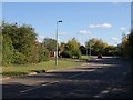
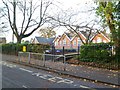
Castleman Way, Ringwood
The modern road has been approximately following the line of the Dorchester to Southampton railway line, and is "named after Charles Castleman, a Wimborne Solicitor, who was responsible for building the original railway line" http://www.dorsetforyou.com/castlemantrailway . Here it begins to veer away to north. On the left is the junction with Waterloo Way into a housing estate whose roads bear the names of four London railway termini.
Image: © Derek Harper
Taken: 12 Oct 2009
0.21 miles