IMAGES TAKEN NEAR TO
Mosquito Way, CHRISTCHURCH, BH23 8HE
Introduction
This page details the photographs taken nearby to Mosquito Way, BH23 8HE by members of the Geograph project.
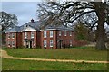
The Geograph project started in 2005 with the aim of publishing, organising and preserving representative images for every square kilometre of Great Britain, Ireland and the Isle of Man.

There are currently over 7.5m images from over14,400 individuals and you can help contribute to the project by visiting https://www.geograph.org.uk
Image Map
Images are licensed for reuse under creativecommons.org/licenses/by-sa/2.0
Notes
- Clicking on the map will re-center to the selected point.
- The higher the marker number, the further away the image location is from the centre of the postcode.
Image Listing (26 Images Found)
Images are licensed for reuse under creativecommons.org/licenses/by-sa/2.0
Image
Details
Distance
1
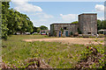
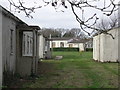
Merryfield Park
The western end of this former RAF camp now used for commercial purposes.
Image: © Peter Facey
Taken: 6 Jun 2010
0.00 miles
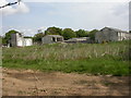
2
Merryfield Park
The western end of this former RAF camp now used for commercial purposes. Seen from footpath.
Image: © Peter Facey
Taken: 6 Jun 2010
0.01 miles
3
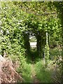
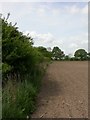
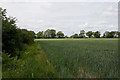
Light at the end of the tunnel!
After 100m of almost canopy-like hedgerow, the footpath from Derritt Lane passes into open country.
Image: © Mike Faherty
Taken: 10 May 2009
0.04 miles
4
Sopley Camp
Formerly the home of RAF Sopley, http://www.subbrit.org.uk/rsg/sites/s/sopley/index4.html , built 1952 to house radar apparatus, with accommodation for 450 personnel. The building to the left housed an emergency generator. The camp closed in 1974, and has subsequently been used to house the Household Cavalry for rest & recreation; to house Vietnamese refugees, and currently, renamed Merryfield Park, as a business park.http://archive.thisisdorset.net/2007/1/24/122448.html
Image: © Mike Faherty
Taken: 10 May 2009
0.05 miles
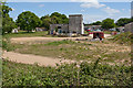
5
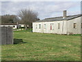
Sopley Camp - former military barracks
Was used to house the Vietnamese "boat people" from 1979 to 1981. Now in private hands.
Image: © mike smith
Taken: 10 Mar 2007
0.05 miles
6
Sopley Camp - former military barracks
Was used to house the Vietnamese "boat people" from 1979 to 1981. Now in private hands.
Image: © mike smith
Taken: 10 Mar 2007
0.05 miles
7
Bransgore, field boundary
The footpath from Bransgore to Ripley passes along the edge of this recently ploughed field; a few footprints point the way.
Image: © Mike Faherty
Taken: 10 May 2009
0.08 miles
8
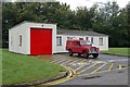
Sopley Camp old fire station
Sopley Camp old RAF fire station, Merryfield Park, Derrit Lane, Bransgore, Dorset, continues to be used as a fire station by a private company offering fire training services
Image: © Kevin Hale
Taken: 16 Oct 2007
0.09 miles
9
Houses at Heatherstone Grange
New housing on the site of the former RAF Sopley Camp.
Image: © David Martin
Taken: 30 Nov 2019
0.10 miles
10
Footpath from Merryfield Park to Ripley
From the look of it, not much frequented.
Image: © Peter Facey
Taken: 6 Jun 2010
0.12 miles