IMAGES TAKEN NEAR TO
Redcliffe Close, CHRISTCHURCH, BH23 7NA
Introduction
This page details the photographs taken nearby to Redcliffe Close, BH23 7NA by members of the Geograph project.
The Geograph project started in 2005 with the aim of publishing, organising and preserving representative images for every square kilometre of Great Britain, Ireland and the Isle of Man.

There are currently over 7.5m images from over14,400 individuals and you can help contribute to the project by visiting https://www.geograph.org.uk
Image Map
Images are licensed for reuse under creativecommons.org/licenses/by-sa/2.0
Notes
- Clicking on the map will re-center to the selected point.
- The higher the marker number, the further away the image location is from the centre of the postcode.
Image Listing (24 Images Found)
Images are licensed for reuse under creativecommons.org/licenses/by-sa/2.0
Image
Details
Distance
1
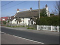
Burton, Silbury & Lilac Cottages
Thatched cottages on Stony Lane (B3347); English Heritage-listed http://www.imagesofengland.org.uk/Details/default.aspx?pid=2&id=101679
Image: © Mike Faherty
Taken: 22 Mar 2009
0.10 miles
2
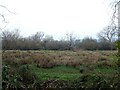
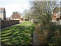
Stream at Burton
This watercourse, unnamed on maps, rises in the fields to the north of Burton,
and joins the near-by River Avon.
Image: © mike smith
Taken: 8 Feb 2011
0.12 miles
3
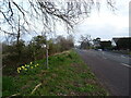
Burton: postbox № BH23 73, Campbell Road
One of five postboxes in Burton.
Image: © Chris Downer
Taken: 23 Jul 2009
0.12 miles
4
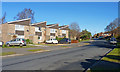
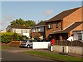
Campbell Road, Burton
This road, also a bus route, cuts through the modern housing developments of north Burton.
The roof line of the houses on the left creates an interesting sawtooth pattern.
Image: © mike smith
Taken: 8 Feb 2011
0.13 miles
6
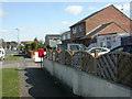
Burton, Campbell Road
Road with modern housing; compare with Image around the corner. Pillar postbox in the foreground is EIIR and bears the number BH23 73.
Image: © Mike Faherty
Taken: 22 Mar 2009
0.13 miles
7
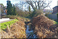
Burton, Clockhouse Stream
A stream that rises near Bransgore and flows into the Avon South of Burton; seen here from a footbridge on the Avon Valley Path near Burnham Road.
Image: © Mike Faherty
Taken: 22 Mar 2009
0.13 miles
9
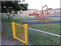
Playground area
View from the Avon Valley footpath.
Image: © Mat Tuck
Taken: 9 Jul 2013
0.14 miles