
IMAGES TAKEN NEAR TO
Hawthorn Road, CHRISTCHURCH, BH23 7JA
Introduction
This page details the photographs taken nearby to Hawthorn Road, BH23 7JA by members of the Geograph project.
The Geograph project started in 2005 with the aim of publishing, organising and preserving representative images for every square kilometre of Great Britain, Ireland and the Isle of Man.

There are currently over 7.5m images from over14,400 individuals and you can help contribute to the project by visiting https://www.geograph.org.uk
Image Map
Images are licensed for reuse under creativecommons.org/licenses/by-sa/2.0
Notes
- Clicking on the map will re-center to the selected point.
- The higher the marker number, the further away the image location is from the centre of the postcode.
Image Listing (29 Images Found)
Images are licensed for reuse under creativecommons.org/licenses/by-sa/2.0
Image
Details
Distance
1
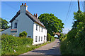
Thatched Cottages at Somerford
This pleasant-looking cottage (actually two semi-detached cottages) is only yards from the busy Christchurch Bypass, and close to the Bournemouth main railway line (see bridge in distance). When the photo was taken, one semi was for sale at £210,000.
Image: © mike smith
Taken: 21 May 2011
0.02 miles
2
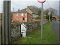
Milepost, Burton
One of a series from Christchurch to Ringwood; cast-iron, cast by Armfields of Ringwood. Legend on other side reads "1/2 / Christ / Church". Staple Cross farmhouse in the background.
Image: © Mike Faherty
Taken: 24 Nov 2008
0.05 miles
3
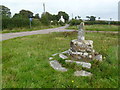
Somerford, wayside cross
Staple Cross, at the junction of Salisbury Road, Hawthorn Road and Ambury Lane.
Image: © Mike Faherty
Taken: 25 Sep 2011
0.05 miles
4
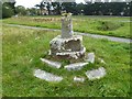
Old Wayside Cross on Salisbury Road, Christchurch
Staple Cross, old shaft, base & steps, by the UC road, in parish of Christchurch (Christchurch District), Salisbury Road, at the junction of Hawthorn Road and Ambury Lane, just north of the A35 Christchurch by-pass, on green area back from road.
Scheduled Monument.
List Entry Number: 1002369 https://historicengland.org.uk/listing/the-list/list-entry/1002369
To be surveyed
Milestone Society National ID: DOCH_CHR
Image: © M Faherty
Taken: 25 Sep 2011
0.05 miles
5
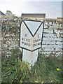
Old Milepost by Salisbury Road, Staple Cross, south of Burton
Cast iron post by the UC road, in parish of BURTON (CHRISTCHURCH District), 100m North of junction with the A35 at Staple Cross, against farmyard wall, on South-west side of road. Ringwood cast iron post erected by the County Council in the 19th century.
Inscription reads:-
: 8 / RING / WOOD : : ½ / CHRIST / CHURCH :
Maker:-
: J. ARMFIELD / RINGWOOD. :
Grade II Listed. List Entry Number: 1110043
https://historicengland.org.uk/listing/the-list/list-entry/1110043
Milestone Society National ID: HA_RICH08.
Image: © Milestone Society
Taken: 27 Mar 2017
0.05 miles
7
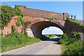
Railway Bridge at Somerford
This railway bridge carries the main line between London, Bournemouth, and Weymouth. The maximum height warning sign reads 15' 9".
Image: © mike smith
Taken: 21 May 2011
0.05 miles

10
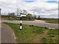
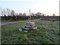
Direction Sign ? Signpost at Burton Road End
Located beside the footpath on grass triangle at Burton road end, close to the junction with the A35 in Burton parish. 2 arms and annulus finial. See https://www.geograph.org.uk/photo/6037383 and https://www.geograph.org.uk/photo/495506 before restoration
Milestone Society National ID: HA_SZ1793
Image: © Z La Gumina
Taken: 5 Apr 2021
0.06 miles