
IMAGES TAKEN NEAR TO
Brinsons Close, CHRISTCHURCH, BH23 7HS
Introduction
This page details the photographs taken nearby to Brinsons Close, BH23 7HS by members of the Geograph project.
The Geograph project started in 2005 with the aim of publishing, organising and preserving representative images for every square kilometre of Great Britain, Ireland and the Isle of Man.

There are currently over 7.5m images from over14,400 individuals and you can help contribute to the project by visiting https://www.geograph.org.uk
Image Map
Images are licensed for reuse under creativecommons.org/licenses/by-sa/2.0
Notes
- Clicking on the map will re-center to the selected point.
- The higher the marker number, the further away the image location is from the centre of the postcode.
Image Listing (62 Images Found)
Images are licensed for reuse under creativecommons.org/licenses/by-sa/2.0
Image
Details
Distance
1
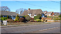
Houses on Salisbury Road, Burton
Although much of the housing in Burton is modern, there are a few older properties, such as the thatched cottage seen in the centre above.
Image: © mike smith
Taken: 8 Feb 2011
0.05 miles
2
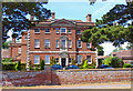
Burton Hall
This imposing building was built in 1750 and is Grade II* listed. It is now divided into individual apartments.
Image: © mike smith
Taken: 6 Jul 2010
0.07 miles
3
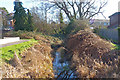
Stream at Burton
This watercourse, unnamed on maps, rises in the fields to the north of Burton,
and joins the near-by River Avon.
Image: © mike smith
Taken: 8 Feb 2011
0.07 miles
4
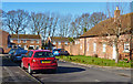
Burton Hall Close
This new development is built on land that was once part of the Burton Hall estate. One of the original buildings can be seen on the right.
Image: © mike smith
Taken: 8 Feb 2011
0.08 miles
5
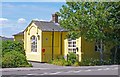
Burton Day Nursery
Facility for youngsters whose parents are working. It is an old school house (still shown as a school on some maps), painted pale yellow, presumably to make it attractive to the kids.
Image: © mike smith
Taken: 6 Jul 2010
0.08 miles
6
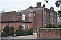
Burton Hall
Former manor house now subdivided into apartments.
Image: © David Martin
Taken: 24 Jan 2022
0.09 miles
7
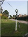
Burton, fingerpost
Almost redundant, & very neglected; at the junction of Salisbury Road & Preston Lane. Two arms are missing, and the one remaining has a plastic label for a care home stuck over what was probably Bockhampton or Waterditch. Note that Burton is now in Dorset; this post pre-dates local governement reorganisation in 1974; Dorset Highways have chosen not to paint HAMPSHIRE black.
Image: © Mike Faherty
Taken: 21 Mar 2009
0.09 miles
8
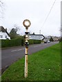
Direction Sign - Signpost by Preston Lane, Burton, Christchurch
Annulus finial - 1 unofficial arm; Hants. halo by the UC road (was B3347), in parish of Burton (Christchurch District), Salisbury Road junction with Preston Lane.
Surveyed
Milestone Society National ID: HA_SZ1694
Image: © Milestone Society
Taken: Unknown
0.09 miles
9
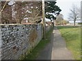
Burton Hall, wall
C18 wall in front of Image, listed by English Heritage http://www.imagesofengland.org.uk/Details/Default.aspx?id=101659&mode=adv Suitably lichen-encrusted.
Image: © Mike Faherty
Taken: 21 Mar 2009
0.09 miles
10
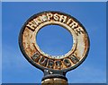
Vintage Burton Sign
This is on the corner of Salisbury Road and Preston Lane, only just in the square. Since the local government shake-up in 1974, Burton has been a part of Dorset.
Image: © mike smith
Taken: 6 Jul 2010
0.09 miles