IMAGES TAKEN NEAR TO
Dudmoor Lane, CHRISTCHURCH, BH23 6BQ
Introduction
This page details the photographs taken nearby to Dudmoor Lane, BH23 6BQ by members of the Geograph project.
The Geograph project started in 2005 with the aim of publishing, organising and preserving representative images for every square kilometre of Great Britain, Ireland and the Isle of Man.

There are currently over 7.5m images from over14,400 individuals and you can help contribute to the project by visiting https://www.geograph.org.uk
Image Map
Images are licensed for reuse under creativecommons.org/licenses/by-sa/2.0
Notes
- Clicking on the map will re-center to the selected point.
- The higher the marker number, the further away the image location is from the centre of the postcode.
Image Listing (14 Images Found)
Images are licensed for reuse under creativecommons.org/licenses/by-sa/2.0
Image
Details
Distance
1
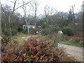
Dudmoor Lane, caravans
Like other local marginal suburban/rural sites, property seems either to be caravans or wooden buildings; perhaps planning regulations are laxer for them.
Image: © Mike Faherty
Taken: 19 Jan 2009
0.02 miles
2
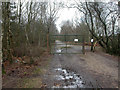
Dudmoor Lane, common entrance
Gate barring unauthorised traffic from Town Common, managed by the Herpetogical Conservation Trust http://www.herpconstrust.org.uk/about.htm
Image: © Mike Faherty
Taken: 19 Jan 2009
0.08 miles
3
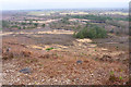
The eastern slopes of St Catherine's Hill
From this vantage point, a wide view of the Avon Valley can be seen.
Image: © mike smith
Taken: 2 Feb 2011
0.09 miles
4
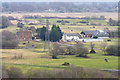
Briars Farm
This farm is not named on the local OS map, but is described as above on the local street atlas.
Image: © mike smith
Taken: 2 Feb 2011
0.11 miles
5
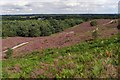
North-east slopes of St Catherine's Hill, Town Common
Looking down along the undulating slopes of St Catherine's Hill, with the heather in bloom.
Image: © Jim Champion
Taken: 29 Jul 2007
0.15 miles
6
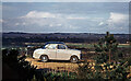
Standard 10 saloon on the east side of St Catherine's Hill c.1965
Whatever possessed my late father to drive up St Catherine's Hill, and then to photograph the "crime scene" with the Avon Valley as a backdrop, I have absolutely no idea. It would certainly be frowned upon today, and I'm not at all sure if it is possible to do any longer. He was obviously very proud of his car.
Image: © Ronald Searle
Taken: Unknown
0.15 miles
7
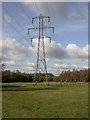
Electricity pylons, Dudmoor
Pylons striding north-west from near Dudmoor Farm. Land here is damp acidic grassland, used mainly for horse grazing.
Image: © Mike Faherty
Taken: 31 Oct 2008
0.16 miles

10
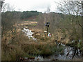
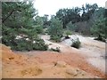
Town Common, fire beaters
Like all Dorset commons, Town Common is susceptible to fire damage, accidental or deliberate. It has rained heavily recently; the apparent stream in the centre is in fact a footpath. In the distance, Blackwater Hill.
Image: © Mike Faherty
Taken: 19 Jan 2009
0.21 miles