IMAGES TAKEN NEAR TO
Miller Road, CHRISTCHURCH, BH23 3SX
Introduction
This page details the photographs taken nearby to Miller Road, BH23 3SX by members of the Geograph project.
The Geograph project started in 2005 with the aim of publishing, organising and preserving representative images for every square kilometre of Great Britain, Ireland and the Isle of Man.

There are currently over 7.5m images from over14,400 individuals and you can help contribute to the project by visiting https://www.geograph.org.uk
Image Map (Loading...)


Getting Data...Please wait
Leaflet Map data © OpenStreetMap
Images are licensed for reuse under creativecommons.org/licenses/by-sa/2.0
Notes
- Clicking on the map will re-center to the selected point.
- The higher the marker number, the further away the image location is from the centre of the postcode.
Image Listing (18 Images Found)
Images are licensed for reuse under creativecommons.org/licenses/by-sa/2.0
Image
Details
Distance
1
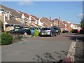
Modern Housing at Purewell
These modern homes have been built recently on land adjacent to Purewell Meadows. The local nature reserve has been broken into separated chunks by these developments.
Image: © mike smith
Taken: 21 Oct 2007
0.03 miles
2
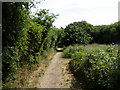
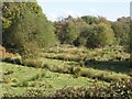
Purewell Meadows, footpath
Through Purewell Meadows Local Nature Reserve, from Purewell Cross Road to Normandy Drive.
Image: © Mike Faherty
Taken: 27 Jun 2010
0.04 miles
3
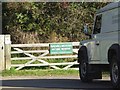
Main Entrance to Purewell Meadows Nature Reserve
This area covers 8 hectares, and is maintained by the Christchurch Borough Countryside Service, with help from local volunteers.
Image: © mike smith
Taken: 21 Oct 2007
0.08 miles
4
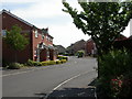
Purewell, Le Patourel Close
Modern housing off Normandy Drive; probably named after Herbert Le Patourel, VC-awarded officer in the Hampshire Regiment in 1942.
Image: © Mike Faherty
Taken: 27 Jun 2010
0.09 miles
5
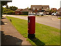
Christchurch: postbox № BH23 107, Normandy Drive
This postbox serves a modern housing estate and is emptied finally at 5pm on weekdays and at noon on Saturdays.
Image: © Chris Downer
Taken: 9 Aug 2009
0.09 miles
6
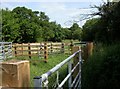
Cattle Pens at Purewell Meadows
These meadows are a local nature reserve, and cattle are used to graze the land to help keep the vegetation under control. The animals used are Galloway Cattle which are able to tolerate the damp conditions on the meadows in winter.
Image: © mike smith
Taken: 21 Oct 2007
0.09 miles
7
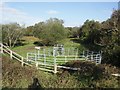
Purewell Meadows, stock pen
Off Purewell Cross Road; for use by cattle grazing in the adjacent watermeadows. http://www.dorsetforyou.com/386519
Image: © Mike Faherty
Taken: 27 Jun 2010
0.10 miles
8
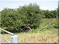
Purewell Meadows, grazing land
Cattle (currently sheltering from the sun under the tree to the left) have been introduced here to control rank vegetation. http://www.dorsetforyou.com/386519
Image: © Mike Faherty
Taken: 27 Jun 2010
0.11 miles
9
Purewell Meadows Nature Reserve
This public land is popular with walkers and dog owners.
Image: © mike smith
Taken: 21 Oct 2007
0.11 miles
10
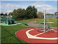
Playground at Scotts Hill Lane
Just off Purwell Cross Road, this is a safe play area for children living on the adjacent new housing developments.
Image: © mike smith
Taken: 21 Oct 2007
0.12 miles