IMAGES TAKEN NEAR TO
Sopers Lane, CHRISTCHURCH, BH23 1JE
Introduction
This page details the photographs taken nearby to Sopers Lane, BH23 1JE by members of the Geograph project.
The Geograph project started in 2005 with the aim of publishing, organising and preserving representative images for every square kilometre of Great Britain, Ireland and the Isle of Man.

There are currently over 7.5m images from over14,400 individuals and you can help contribute to the project by visiting https://www.geograph.org.uk
Image Map (Loading...)


Getting Data...Please wait
Leaflet Map data © OpenStreetMap
Images are licensed for reuse under creativecommons.org/licenses/by-sa/2.0
Notes
- Clicking on the map will re-center to the selected point.
- The higher the marker number, the further away the image location is from the centre of the postcode.
Image Listing (331 Images Found)
Images are licensed for reuse under creativecommons.org/licenses/by-sa/2.0
Image
Details
Distance
1
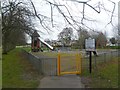
Christchurch, play area
In Barrack Road Recreation Ground. http://www.dorsetforyou.com/390446
Image: © Mike Faherty
Taken: 8 Feb 2012
0.05 miles
2
Christchurch, Anglo-Saxon wall
Between car park & Druitt Gardens; apparently the only surviving remnant of wall of this age in the country, albeit restored. Ironstone; the original mortar was made from burnt oyster shells.
Image: © Mike Faherty
Taken: 9 Aug 2009
0.07 miles
3

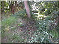
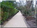
Avenue of leaning trees
A footpath, marked on the map, through the park flanked by leaning trees.
Image: © Chris Downer
Taken: Unknown
0.07 miles
4
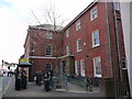
Christchurch - Library
The Druitt public library.
Image: © Chris Talbot
Taken: 13 Mar 2010
0.08 miles
5
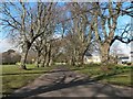
Christchurch: avenue of trees across Barrack Road rec
This path cuts diagonally across the corner of Barrack Road recreation ground and is arched by a fine avenue of trees, all leaning slightly to the northeast.
Image: © Chris Downer
Taken: 17 Feb 2018
0.09 miles
6
Christchurch, Creedy Path
Path from Wick Lane to Sopers Lane, running through Druitt Gardens. Like the gardens (to the right), the path is being refurbished. According to a poster, this is one of Christchurch's oldest paths, which probably once connected the priory and a leper hospital off Barrack Road. It seems that the path will in future also be used by cyclists: http://www.dorsetecho.co.uk/archive/2011/06/19/Latest+News+(be_latest+news)/9092355.Cyclists_on_road_to_success/
Image: © Mike Faherty
Taken: 1 Jan 2012
0.09 miles
7
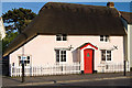
Buildings of Christchurch (a selection): 56 Sopers Lane
C18/early C19 cottage with a thatched roof. Listed Grade II.
https://historicengland.org.uk/listing/the-list/list-entry/1110051
Image: © Mike Searle
Taken: 17 May 2014
0.10 miles
8
New Zealand Gardens, Christchurch.
A Public garden which emphasises the links between Christchurch, Dorset, and Christchurch, New Zealand.
Image: © Ron Hann
Taken: Unknown
0.10 miles
9
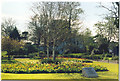
Christchurch.
Another view of the New Zealand Garden.
Image: © Ron Hann
Taken: Unknown
0.10 miles
10
Christchurch - Saxon Square Shopping Centre
This shopping development was built in 1983.
Image: © Chris Talbot
Taken: 13 Mar 2010
0.10 miles