IMAGES TAKEN NEAR TO
Haythorne Common, WIMBORNE, BH21 7JQ
Introduction
This page details the photographs taken nearby to Haythorne Common, BH21 7JQ by members of the Geograph project.
The Geograph project started in 2005 with the aim of publishing, organising and preserving representative images for every square kilometre of Great Britain, Ireland and the Isle of Man.

There are currently over 7.5m images from over14,400 individuals and you can help contribute to the project by visiting https://www.geograph.org.uk
Image Map (Loading...)


Getting Data...Please wait
Leaflet Map data © OpenStreetMap
Images are licensed for reuse under creativecommons.org/licenses/by-sa/2.0
Notes
- Clicking on the map will re-center to the selected point.
- The higher the marker number, the further away the image location is from the centre of the postcode.
Image Listing (15 Images Found)
Images are licensed for reuse under creativecommons.org/licenses/by-sa/2.0
Image
Details
Distance
1
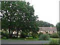
Haythorne: houses and big trees
A pair of large oaks in the centre of Haythorne tower over the line of council houses alongside.
Image: © Chris Downer
Taken: 31 Aug 2008
0.01 miles
2
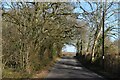
Haythorne: arriving from the north
The village of Haythorne is so small that, from the welcome sign here, it is virtually possible to see the one for oncoming traffic (see Image) at the top of the hill: only the tufty plant in the middle distance prevents this.
Image: © Chris Downer
Taken: 31 Aug 2008
0.03 miles
3
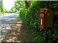
Haythorne: postbox № BH21 143
The postbox stands in an almost perpetually shady spot under a weeping willow tree - see Image for a wider view, with the box on the right.
Image: © Chris Downer
Taken: 9 Jun 2013
0.04 miles
4
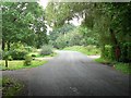
Haythorne: the lane through the village
The lane through this tiny village, with Image on the right.
Image: © Chris Downer
Taken: 31 Aug 2008
0.05 miles
6
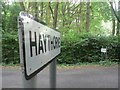
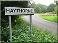
Horton: arriving at Haythorne
These two signs mark the fairly academic border of Horton and Haythorne; the Haythorne sign has been present since it was spelt without an 'e' on the map, but the map now agrees.
Image: © Chris Downer
Taken: 31 Aug 2008
0.09 miles
7
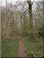
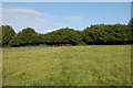
Haythorne Common
Open-access woodland; mainly oak, with some beech and holly.
Image: © Mike Faherty
Taken: 20 Mar 2011
0.09 miles
8
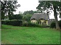
Haythorne: Haythorn Cottage
This attractive thatched cottage reflects the older spelling of the village name, going by previous editions of the Ordnance Survey map.
Image: © Chris Downer
Taken: 31 Aug 2008
0.11 miles
9
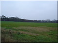
Footpath near Greenlands Farm
Here the path crosses this field diagonally towards Haythorne.
Image: © Trevor Harris
Taken: 4 Aug 2014
0.19 miles