IMAGES TAKEN NEAR TO
Old Barn Farm Road, WIMBORNE, BH21 6SF
Introduction
This page details the photographs taken nearby to Old Barn Farm Road, BH21 6SF by members of the Geograph project.
The Geograph project started in 2005 with the aim of publishing, organising and preserving representative images for every square kilometre of Great Britain, Ireland and the Isle of Man.

There are currently over 7.5m images from over14,400 individuals and you can help contribute to the project by visiting https://www.geograph.org.uk
Image Map (Loading...)


Getting Data...Please wait
Leaflet Map data © OpenStreetMap
Images are licensed for reuse under creativecommons.org/licenses/by-sa/2.0
Notes
- Clicking on the map will re-center to the selected point.
- The higher the marker number, the further away the image location is from the centre of the postcode.
Image Listing (12 Images Found)
Images are licensed for reuse under creativecommons.org/licenses/by-sa/2.0
Image
Details
Distance
1
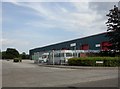
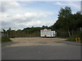
Woolsbridge Industrial Park
The park comprises Old Barn Farm Road, and turnings off it, called "Way" or "Close". This is Liberty Close.
Image: © Mike Faherty
Taken: 8 Aug 2010
0.05 miles
2
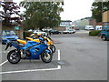
Woolsbridge Industrial Estate
This industrial estate is a motorcyclists mecca with quite a few of the units dealing in the sales and servicing of motorcycles.
Image: © Stuart Buchan
Taken: 5 Oct 2005
0.05 miles
3
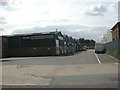
Woolsbridge, Crane Way
Woolsbridge Industrial Park comprises Old Barn Farm Road, with turnings off it called "Close" or "Way".
Image: © Mike Faherty
Taken: 8 Aug 2010
0.09 miles
4
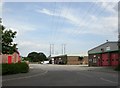
Woolsbridge, power lines
Crossing Old Barn Farm Road, and passing over Azura Close.
Image: © Mike Faherty
Taken: 8 Aug 2010
0.10 miles
6
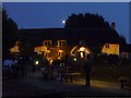
Woolsbridge: moon over the Old Barn Farm Inn
An attractive, thatched country pub in an almost incongruous setting alongside an out-of-town industrial estate. Smoker or not, it's been a beautiful evening to be sat outside.
Image: © Chris Downer
Taken: 3 Jul 2009
0.16 miles
7
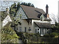
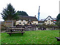
Woolsbridge, Old Barn Farm
Pub on Verwood Road, shown on old maps as Woolsbridge Farm. Difficult to photograph as it is situated right at the Northern edge of this square. Externally, large car park, garden, pond & dovecote (visible at the back); internally, L-shaped bar, eating & drinking areas surrounding it; darts, low ceilings & wooden beams. For some customer reviews, http://www.beerintheevening.com/pubs/s/22/22130/Old_Barn_Farm/Three_Legged_Cross
Image: © Mike Faherty
Taken: 14 Aug 2009
0.16 miles
8
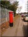
Woolsbridge: postbox № BH21 123, Old Barn Farm Road
This Elizabeth II-reign postbox chiefly serves the industrial estate, of which Old Barn Farm Road is the main access road. It is emptied at 4:30pm on weekdays and at 9am on Saturdays.
The cars parked along here are most likely those visiting the large Sunday car-boot sale across the road. This is probably easier than fighting with their car park!
Image: © Chris Downer
Taken: 29 Mar 2009
0.16 miles
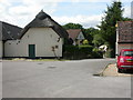
9
Woolsbridge Snack Bar
Off Old Barn Farm Road, serving the adjoining industrial estate. Unfortunately closed today!
Image: © Mike Faherty
Taken: 8 Aug 2010
0.16 miles
10
The Three Legged Cross Inn
Until recently the pub was known as the Old Barn Farm Inn. It is on the edge of an industrial estate. For a view of the sign Image
Image: © Maigheach-gheal
Taken: 15 Dec 2010
0.16 miles