IMAGES TAKEN NEAR TO
West Moors Road, WIMBORNE, BH21 6QP
Introduction
This page details the photographs taken nearby to West Moors Road, BH21 6QP by members of the Geograph project.
The Geograph project started in 2005 with the aim of publishing, organising and preserving representative images for every square kilometre of Great Britain, Ireland and the Isle of Man.

There are currently over 7.5m images from over14,400 individuals and you can help contribute to the project by visiting https://www.geograph.org.uk
Image Map
Images are licensed for reuse under creativecommons.org/licenses/by-sa/2.0
Notes
- Clicking on the map will re-center to the selected point.
- The higher the marker number, the further away the image location is from the centre of the postcode.
Image Listing (40 Images Found)
Images are licensed for reuse under creativecommons.org/licenses/by-sa/2.0
Image
Details
Distance
1
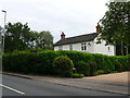
House on West Moors Rd
This house is in the very north east corner of the grid square where the road in the foreground (West Moors Rd the B3072) just crosses into the grid square. The junction with Ringwood Rd is just out of image to the left.
Image: © Nigel Mykura
Taken: 27 Jun 2012
0.04 miles
2
Three Legged Cross, Greycot Close
Short cul-de-sac off Ringwood Road, with modern bungalows.
Image: © Mike Faherty
Taken: 28 Dec 2009
0.08 miles
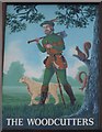
3
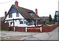
The Woodcutters, Three Legged Cross
The pub was once called the Travellers Rest.
Image: © Maigheach-gheal
Taken: 29 Dec 2008
0.08 miles
5
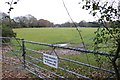
Fields at Three Legged Cross
No visitors wanted here in this field just off the road between Three Legged Cross and Lower Mannington.
Image: © Nigel Mykura
Taken: 26 Nov 2008
0.09 miles
6

Three Legged Cross: signs on Ringwood Road
These signposts mark the point where the B3072, from West Moors, turns right onto Ringwood Road for a short distance before doing a left to continue to Verwood.
The finial from the original finger-post has been retained, giving location and grid reference – see Image
Image: © Chris Downer
Taken: 7 Mar 2010
0.09 miles
7
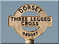
Three Legged Cross: signpost detail
A close-up of the finial from the original finger-post, giving location and grid reference details. See Image for the signpost as it looks now.
Image: © Chris Downer
Taken: 7 Mar 2010
0.09 miles

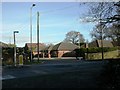
9
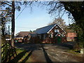
Three Legged Cross, village hall
In Village Hall Lane; occasional meeting place for Verwood Town Council.
Image: © Mike Faherty
Taken: 28 Dec 2009
0.10 miles
10
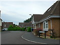
Fern Bank
This is a small residential road consisting mainly of modern bungalows on a small estate tucked in the triangle between Ringwood Rd and West Moors Rd in the very north western corner of the grid square.
Image: © Nigel Mykura
Taken: 27 Jun 2012
0.11 miles