IMAGES TAKEN NEAR TO
Mead Lane, WIMBORNE, BH21 5HG
Introduction
This page details the photographs taken nearby to Mead Lane, BH21 5HG by members of the Geograph project.
The Geograph project started in 2005 with the aim of publishing, organising and preserving representative images for every square kilometre of Great Britain, Ireland and the Isle of Man.

There are currently over 7.5m images from over14,400 individuals and you can help contribute to the project by visiting https://www.geograph.org.uk
Image Map (Loading...)


Getting Data...Please wait
Leaflet Map data © OpenStreetMap
Images are licensed for reuse under creativecommons.org/licenses/by-sa/2.0
Notes
- Clicking on the map will re-center to the selected point.
- The higher the marker number, the further away the image location is from the centre of the postcode.
Image Listing (35 Images Found)
Images are licensed for reuse under creativecommons.org/licenses/by-sa/2.0
Image
Details
Distance
2
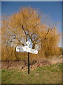
Gussage All Saints: Ton Bridge finger-post
This traditional Dorset signpost apparently retains its original finial, giving location and grid reference details, although I believe it is in fact a modern replica. The willow behind it is catching the afternoon sun rather fetchingly.
For a close-up of the finial, see Image
Image: © Chris Downer
Taken: 7 Mar 2010
0.15 miles
3
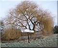
Finger post, Ton Bridge
The finger post has a six figure grid reference on the roundel.
Image: © Maigheach-gheal
Taken: 31 Jan 2010
0.15 miles
4

Gussage All Saints: detail of Ton Bridge finger-post
A close-up of the finial of the finger-post (see Image), giving location and grid reference details.
Image: © Chris Downer
Taken: 7 Mar 2010
0.15 miles
5
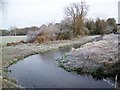
Stream, Ton Bridge
The stream is a tributary of the River Allen.
Image: © Maigheach-gheal
Taken: 31 Jan 2010
0.15 miles
6
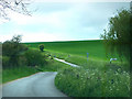
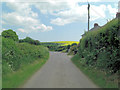
From Custard Hill to Whiteway Hill
Signpost points up Mead Lane
Image: © Chris Gunns
Taken: 26 Apr 2009
0.16 miles
7
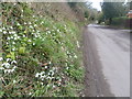
Gussage All Saints, snowdrops
Plentiful on the verges of the village street.
Image: © Mike Faherty
Taken: 14 Feb 2012
0.16 miles
8

Gussage Social Club
On the village street in Gussage All Saints.
Image: © Mike Faherty
Taken: 8 Aug 2009
0.16 miles
9
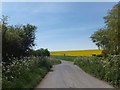
Rape field on Whiteway Hill
Directly ahead is a road junction with Mead Lane
Image: © David Smith
Taken: 3 May 2014
0.16 miles
10

Gussage All Saints, thatched cottages
Two English Heritage-listed cottages, the nearer Elm Tree Cottage, timber framed with brick infill http://www.imagesofengland.org.uk/Details/Default.aspx?id=107380&mode=adv and the farther Cobwebs, rendered brick http://www.imagesofengland.org.uk/Details/Default.aspx?id=107381&mode=adv
Image: © Mike Faherty
Taken: 8 Aug 2009
0.16 miles