IMAGES TAKEN NEAR TO
Sheephouse Drove, WIMBORNE, BH21 5BL
Introduction
This page details the photographs taken nearby to Sheephouse Drove, BH21 5BL by members of the Geograph project.
The Geograph project started in 2005 with the aim of publishing, organising and preserving representative images for every square kilometre of Great Britain, Ireland and the Isle of Man.

There are currently over 7.5m images from over14,400 individuals and you can help contribute to the project by visiting https://www.geograph.org.uk
Image Map
Images are licensed for reuse under creativecommons.org/licenses/by-sa/2.0
Notes
- Clicking on the map will re-center to the selected point.
- The higher the marker number, the further away the image location is from the centre of the postcode.
Image Listing (13 Images Found)
Images are licensed for reuse under creativecommons.org/licenses/by-sa/2.0
Image
Details
Distance
1
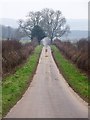
Roman Road near Manswood
The Roman Road from Sheephouse Drove to Whitchampton.
Image: © Maigheach-gheal
Taken: 31 Jan 2009
0.14 miles
2
Witchampton: the Roman road from Sheephouse Drove
The straight course of a Roman road, running close to north from Badbury Rings, can be traced intermittently in this area – behind us, it peters out but the course can be rejoined farther north.
For comment on the signpost, see Image
Image: © Chris Downer
Taken: 7 Mar 2010
0.15 miles
3
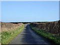
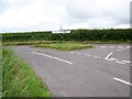
A Roman road
The Romans continued straight on at the junction ahead, but the next section has fallen into total disuse.
Image: © Robin Webster
Taken: 2 Mar 2017
0.18 miles
4
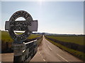
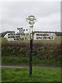
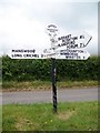
Witchampton: signpost at Sheephouse Drove
An old Dorset signpost with the circular finial which gives location name and six-figure grid reference.
For a close-up of the finial, see Image
Image: © Chris Downer
Taken: 30 Nov 2008
0.19 miles
5
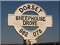
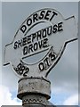
Witchampton: detail of Sheephouse Drove signpost
A close-up of the finial of the finger-post (see Image), giving location and grid reference details.
Image: © Chris Downer
Taken: 7 Mar 2010
0.19 miles
7
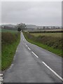
Follow the Roman Road from Sheephouse Drove
This road is on the exact alignment of the Roman Road which a few miles north of here is labelled Ackling Dyke.
Image: © Toby
Taken: 24 Nov 2006
0.20 miles
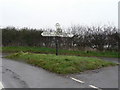
8
Road junction, Sheephouse Drove
Junction of minor roads near Manswood. The finger-post stands proud on its piece of grass.
Image: © Maigheach-gheal
Taken: 8 Jun 2010
0.20 miles
9
Finger-post, Sheephouse Drove
Finger-post near Manswood showing the roundel with grid reference. For a wider view Image
Image: © Maigheach-gheal
Taken: 8 Jun 2010
0.20 miles
10
Sign detail, Sheephouse Drove
The roundel with its six figure grid reference. For a wider view Image
Image: © Maigheach-gheal
Taken: 8 Jun 2010
0.20 miles