IMAGES TAKEN NEAR TO
Market Place, WIMBORNE, BH21 4BS
Introduction
This page details the photographs taken nearby to Market Place, BH21 4BS by members of the Geograph project.
The Geograph project started in 2005 with the aim of publishing, organising and preserving representative images for every square kilometre of Great Britain, Ireland and the Isle of Man.

There are currently over 7.5m images from over14,400 individuals and you can help contribute to the project by visiting https://www.geograph.org.uk
Image Map
Images are licensed for reuse under creativecommons.org/licenses/by-sa/2.0
Notes
- Clicking on the map will re-center to the selected point.
- The higher the marker number, the further away the image location is from the centre of the postcode.
Image Listing (129 Images Found)
Images are licensed for reuse under creativecommons.org/licenses/by-sa/2.0
Image
Details
Distance
1
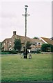
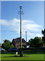
Sturminster Marshall: the maypole on the village green
For more discussion on the maypole, see Image (pictured in winter).
Image: © Chris Downer
Taken: Unknown
0.02 miles
2
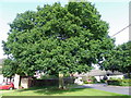
Oak tree, Sturminster Marshall
The tree was planted in 1887 to celebrate the Golden Jubilee of Queen Victoria's accession to the throne.
Image: © Maigheach-gheal
Taken: 25 Jun 2011
0.02 miles
3
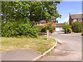
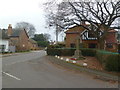
A close off Church Street, Sturminster Marshall
The close is part of Church Street; the upright was presumably a gatepost before these houses were built
Image: © David Smith
Taken: 6 Jul 2015
0.02 miles
4
Maypole, Sturminster Marshall
The first maypole was erected in 1101 after permission for a fair had been granted by the Lord of the Manor, the Earl of Pembroke. Restorations are known to have taken place in 1669, 1857 and 1897 and the present pole follows the 1897 design. The 1986 pole is 35 feet high and is topped by a weather vane designed as a water rat, the village emblem.
Image: © Maigheach-gheal
Taken: 25 Jun 2011
0.02 miles
5
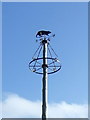
Maypole, Sturminster Marshall
The most recent version of the maypole is surmounted by a weather vane in the shape of a water rat, which is the village’s emblem. For a view of the maypole in its entirety Image
Image: © Maigheach-gheal
Taken: 25 Jun 2011
0.02 miles
6
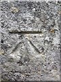
Ordnance Survey Cut Mark
This OS cut mark can be found on the chapel. It marks a point 24.510m above mean sea level.
Image: © Adrian Dust
Taken: 18 Sep 2013
0.03 miles
7
Sturminster Marshall, war memorial
At the corner of High and Kings Street; recording the deaths of 21 fallen in WWI and 8 in WWII.
Image: © Mike Faherty
Taken: 17 Jan 2012
0.03 miles
8
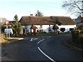
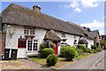
Sturminster Marshall: thatched cottages, High Street
A handsome pair of thatched cottages, 148 and 150 High Street.
Image: © Chris Downer
Taken: 7 Dec 2008
0.03 miles
9
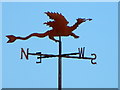
Weather vane, Sturminster Marshall
The word 'vane' comes from the Anglo-Saxon word 'fane', meaning 'flag'. Originally, fabric pennants would show archers the direction of the wind. Later, the cloth flags were replaced by metal ones, decorated with the nobleman's coat of arms. It was understood that shifts in the wind often indicated changes in the weather. Cardinal points were not added until several centuries later.
Image: © Maigheach-gheal
Taken: 25 Jun 2011
0.03 miles