IMAGES TAKEN NEAR TO
Cranfield Avenue, WIMBORNE, BH21 1DE
Introduction
This page details the photographs taken nearby to Cranfield Avenue, BH21 1DE by members of the Geograph project.
The Geograph project started in 2005 with the aim of publishing, organising and preserving representative images for every square kilometre of Great Britain, Ireland and the Isle of Man.

There are currently over 7.5m images from over14,400 individuals and you can help contribute to the project by visiting https://www.geograph.org.uk
Image Map
Images are licensed for reuse under creativecommons.org/licenses/by-sa/2.0
Notes
- Clicking on the map will re-center to the selected point.
- The higher the marker number, the further away the image location is from the centre of the postcode.
Image Listing (14 Images Found)
Images are licensed for reuse under creativecommons.org/licenses/by-sa/2.0
Image
Details
Distance
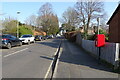
1
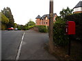
Wimborne Minster: postbox № BH21 2, Cranfield Avenue
This postbox is close to the top of St. John's Hill and halfway up Rowlands Hill, the junction of these being just behind us. The box is emptied at 5:30pm on weekdays and at 11:15am on Saturdays.
Image: © Chris Downer
Taken: 10 Jun 2009
0.08 miles
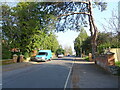
4
Wimborne Minster: postbox № BH21 1, St. John?s Hill
Looking down St. John's Hill, with the Image on the right, past this postbox which has just been fed by both the gentleman in front of us and by the couple beyond him who are about to cross the road.
Talking of the gentleman ahead, note that he is about to walk over a kind of ramp, which slopes downward in three directions and has been affixed to the pavement to assist those boarding the bus.
The postbox is emptied finally at 5:45pm on weekdays and at 11:15 on Saturday mornings.
Image: © Chris Downer
Taken: 10 Jun 2009
0.14 miles
5
St John's Hill
Showing position of Postbox No. BH21 1.
Image: © JThomas
Taken: 23 Mar 2022
0.14 miles
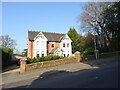
6
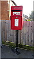
Elizabeth II postbox on St John's Hill
Postbox No. BH21 1.
Image: © JThomas
Taken: 23 Mar 2022
0.15 miles
7
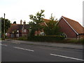
Wimborne Minster: St. John?s First School
A school for 4- to 8-year olds, still housed in its original Victorian premises but with more modern buildings (right) which are built in similar style. Next door, down the hill, is Image
Image: © Chris Downer
Taken: 10 Jun 2009
0.16 miles
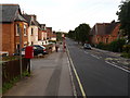
9
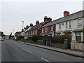
Leigh Rd
These victorian terraced houses are on the north side of Leigh Rd next to the junction with Grenville Rd
Image: © Nigel Mykura
Taken: 6 Mar 2013
0.17 miles
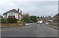
10
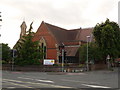
Wimborne Minster: St. John?s from the southeast
An alternative view of the Image, from across the crossroads. Ignoring the traffic lights, this view of the church will never have changed all that much, unlike the view linked above with the modern extensions readily visible.
Image: © Chris Downer
Taken: 10 Jun 2009
0.18 miles