IMAGES TAKEN NEAR TO
Puddletown Road, WAREHAM, BH20 7NG
Introduction
This page details the photographs taken nearby to Puddletown Road, BH20 7NG by members of the Geograph project.
The Geograph project started in 2005 with the aim of publishing, organising and preserving representative images for every square kilometre of Great Britain, Ireland and the Isle of Man.

There are currently over 7.5m images from over14,400 individuals and you can help contribute to the project by visiting https://www.geograph.org.uk
Image Map (Loading...)


Getting Data...Please wait
Leaflet Map data © OpenStreetMap
Images are licensed for reuse under creativecommons.org/licenses/by-sa/2.0
Notes
- Clicking on the map will re-center to the selected point.
- The higher the marker number, the further away the image location is from the centre of the postcode.
Image Listing (5 Images Found)
Images are licensed for reuse under creativecommons.org/licenses/by-sa/2.0
Image
Details
Distance
1
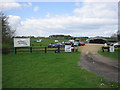
Dorset Gliding Club
The Club is located about half way between the towns of Bere Regis, on the A35, and Wool, on the A352.
http://www.dorsetglidingclub.co.uk/
Image: © John Lamper
Taken: 1 May 2006
0.04 miles
2
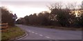
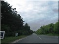
Warning on the road south from Gallows Hill
A necessary warning of hidden dips on a long straight (and generally level) road
Image: © David Smith
Taken: 26 Jan 2018
0.17 miles