IMAGES TAKEN NEAR TO
Elder Road, WAREHAM, BH20 7NB
Introduction
This page details the photographs taken nearby to Elder Road, BH20 7NB by members of the Geograph project.
The Geograph project started in 2005 with the aim of publishing, organising and preserving representative images for every square kilometre of Great Britain, Ireland and the Isle of Man.

There are currently over 7.5m images from over14,400 individuals and you can help contribute to the project by visiting https://www.geograph.org.uk
Image Map (116 Images)


Getting Data...Please wait
Leaflet Map data © OpenStreetMap
Images are licensed for reuse under creativecommons.org/licenses/by-sa/2.0
Notes
- Clicking on the map will re-center to the selected point.
- The higher the marker number, the further away the image location is from the centre of the postcode.
Image Listing (116 Images Found)
Images are licensed for reuse under creativecommons.org/licenses/by-sa/2.0
Image
Details
Distance
1
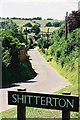
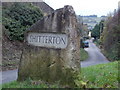
Shitterton, Bere Regis, Dorset
What prompted me to obtain this image was the interesting mix of vertical and skewed horizontal lines in this view.
Image: © Brian Robert Marshall
Taken: 18 Oct 2007
0.07 miles
2
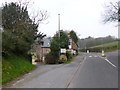
Shitterton
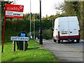
The lower road leads to the delightful village of Sitterton. The name was changed in deference to Queen Victoria when she came to Dorset, but the original name is still used locally. The road on the right goes on to meet the A35 westbound to Dorchester.
Image: © John Lamper
Taken: 1 May 2006
0.08 miles
3
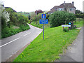
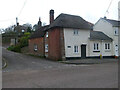
Shitterton: approach road
This road leads down to the picturesque hamlet of Shitterton. The village's name causes the sign to be stolen frequently, this it is often replaced and keeps up with the design of the time. In 2006 it was white: Image
The name of Shitterton was embarrassing enough to the Ordnance Survey that it dropped the H on its maps and called it Sitterton about 20 years ago. The H has recently been restored on both the 1:50,000 and 1:25,000 maps.
Image: © Chris Downer
Taken: Unknown
0.08 miles
4
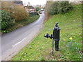
Shitterton, village pump
At the top of the lane leading to the settlement. The pump has been well preserved, though the handle seems fixed. A trademark shows that it was made by Lee, Howl & Co of Tipton: http://www.villagepumps.org.uk/manufs.htm
Image: © Mike Faherty
Taken: 9 Mar 2013
0.08 miles
5
Shitterton: a robust village sign
The standard nameplate on two posts was frequently stolen from this amusingly named hamlet, and this problem was solved by the introduction of this large stone with SHITTERTON inscribed on both sides - this one will surely take some shifting!
See Image for one of the previous signs, and within it a link to another picture.
Image: © Chris Downer
Taken: 28 Nov 2013
0.08 miles
6
Bere Regis, The Old Mill
Former mill on West Street, now a B&B. http://www.theoldmillbereregis.co.uk/
Image: © Mike Faherty
Taken: 26 Feb 2013
0.10 miles
7
Toll Gate Cottage, Bere Regis
A former Toll House at 72 West Street, on the corner of Butt Lane. Used by the Wimborne and Piddletown Turnpike Trust, up to the mid 19ᵗʰ C.
Milestone Society National ID: DO.BER
Image: © Colin Payne
Taken: 17 Mar 2023
0.12 miles
9
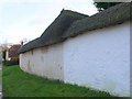
Thatched Cob Wall
Cob walls consisting mainly of mud are frequently protected by a tiled roof to prevent water damage. It is more unusual to see then with a thatched roof such as this one in Shitterton. They are usually rendered with lime mortar. If they are patched with Portland cement mortar as this one had, the Portland mortar will detach eventually as it is too strong and inflexible as well as being waterproof and not allowing the wall to breathe.
Image: © Nigel Mykura
Taken: 1 Feb 2013
0.15 miles
10
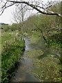
Bere Regis, Bere Stream
Permanent chalk-stream, rising North-west of Bere Regis and flowing into the River Piddle to the South; fast flowing, and could easily be called a river. Visible river vegetation: one of the water crowfoots, probably Ranunculus pencillatus.
Image: © Mike Faherty
Taken: 23 Apr 2009
0.17 miles