IMAGES TAKEN NEAR TO
Roke, WAREHAM, BH20 7JN
Introduction
This page details the photographs taken nearby to Roke, BH20 7JN by members of the Geograph project.
The Geograph project started in 2005 with the aim of publishing, organising and preserving representative images for every square kilometre of Great Britain, Ireland and the Isle of Man.

There are currently over 7.5m images from over14,400 individuals and you can help contribute to the project by visiting https://www.geograph.org.uk
Image Map
Images are licensed for reuse under creativecommons.org/licenses/by-sa/2.0
Notes
- Clicking on the map will re-center to the selected point.
- The higher the marker number, the further away the image location is from the centre of the postcode.
Image Listing (9 Images Found)
Images are licensed for reuse under creativecommons.org/licenses/by-sa/2.0
Image
Details
Distance
1
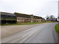
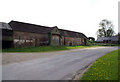
Bere Regis: barns at Roke Farm
Imposing outbuildings alongside the road from Bere Regis to Milborne St. Andrew.
Image: © Chris Downer
Taken: 7 Dec 2008
0.12 miles
2
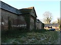
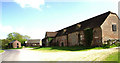
Roke Farm, barn
A large C18 brick barn, with attached wooden cart-shed; listed by English Heritage: http://www.imagesofengland.org.uk/Details/Default.aspx?id=108297&mode=quick
Image: © Mike Faherty
Taken: 9 Mar 2013
0.14 miles
3
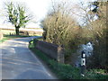
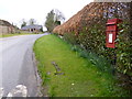
Bere Regis: postbox № BH20 99, Roke Farm
A small postbox serving a few houses at the western extremity of the BH (Bournemouth) postcode area, anything west of here getting post through DT (Dorchester).
Image: © Chris Downer
Taken: 7 Dec 2008
0.15 miles
4
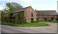
Barn at Roke Farm, Bere Regis
Most of the farm buildings were rebuilt at the close of the 19th century, but the formerly thatched farmhouse and barn date from the 18th century.
Image: © John Lamper
Taken: 3 May 2006
0.16 miles
5
Roke Farm, Bere Regis
Rather unhelpfully, the group of farm buildings is shown as a single block on some 1:50 000 maps. The picture shows that the barn and watermill are some distance apart
Image: © John Lamper
Taken: 3 May 2006
0.16 miles
6
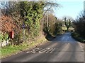
Roke Farm, postbox
An EIIR lamp postbox, ID BH20 99, opposite Roke Farm.
Image: © Mike Faherty
Taken: 9 Mar 2013
0.16 miles
7
Watermill at Roke Farm, Bere Regis
The mill was presumably fed from the pond in SY8396, which is marked as ‘Millum Head’ on 1:25 000 maps and is at a higher elevation.
Image: © John Lamper
Taken: 3 May 2006
0.17 miles
8
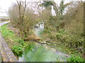
Bere Regis, Bere Stream
A chalk stream that joins River Piddle at Stockley. Looking downstream from near Roke Farm.
Image: © Mike Faherty
Taken: 9 Mar 2013
0.20 miles