IMAGES TAKEN NEAR TO
Shitterton, WAREHAM, BH20 7HU
Introduction
This page details the photographs taken nearby to Shitterton, BH20 7HU by members of the Geograph project.
The Geograph project started in 2005 with the aim of publishing, organising and preserving representative images for every square kilometre of Great Britain, Ireland and the Isle of Man.

There are currently over 7.5m images from over14,400 individuals and you can help contribute to the project by visiting https://www.geograph.org.uk
Image Map
Images are licensed for reuse under creativecommons.org/licenses/by-sa/2.0
Notes
- Clicking on the map will re-center to the selected point.
- The higher the marker number, the further away the image location is from the centre of the postcode.
Image Listing (18 Images Found)
Images are licensed for reuse under creativecommons.org/licenses/by-sa/2.0
Image
Details
Distance
1
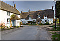
A quiet corner in Shitterton
A pair of thatch cottages, the semi-detached on the left is probably C18. Ahead is Honeycombe Cottage, many C18 additions, but originally a C16 3-bay open-hall house, whose hall was floored over and a chimney inserted circa 1600. Both are grade II listed.
Image: © Mike Searle
Taken: 12 Mar 2014
0.05 miles
2
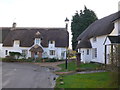
Shitterton
This hamlet at the north western end of bere Regis straddles four grid squares.
Image: © Nigel Mykura
Taken: 1 Feb 2013
0.05 miles
3
Honeycombe Cottage, Shitterton
Mostly C18, but having its origins in the C16 as a hall house, with the jointed cruck roof timbers showing signs of smoke blackening. The hall was floored over and a chimney inserted circa 1600. Grade II listed. http://www.imagesofengland.org.uk/Details/Default.aspx?id=108306&mode=adv
Image: © Mike Searle
Taken: 12 Mar 2014
0.05 miles
4
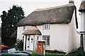
Shitterton: thatched cottage and postbox
The Image stands outside an attractive thatched cottage in Shitterton village.
The name of Shitterton was embarrassing enough to the Ordnance Survey that it dropped the H on its maps and called it Sitterton about 20 years ago. I note from get-a-map that the 1:50,000 currently still refers to it as Sitterton but the 1:25,000 map has restored the H.
Update in March 2008: I notice that the H has now also been restored at the 1:50,000 scale as well!
Image: © Chris Downer
Taken: Unknown
0.06 miles
5
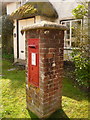
Shitterton: postbox № BH20 101
A George V-reign postbox set into a brick pillar by the bend in the road. It is emptied finally at 4:30pm on weekdays and at 8am on Saturdays.
Image: © Chris Downer
Taken: 10 Apr 2010
0.06 miles
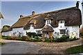
6
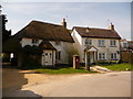
Shitterton: cottages on the corner
An attractive pair of cottages – one thatched – on the bend in the road through this quaint village, almost a suburb of Bere Regis.
Image: © Chris Downer
Taken: 10 Apr 2010
0.06 miles
7
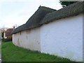
Thatched Cob Wall
Cob walls consisting mainly of mud are frequently protected by a tiled roof to prevent water damage. It is more unusual to see then with a thatched roof such as this one in Shitterton. They are usually rendered with lime mortar. If they are patched with Portland cement mortar as this one had, the Portland mortar will detach eventually as it is too strong and inflexible as well as being waterproof and not allowing the wall to breathe.
Image: © Nigel Mykura
Taken: 1 Feb 2013
0.07 miles
8
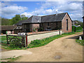
Shitterton Farm Cottages
The buildings here form part of the old Shitterton Farm complex, most of which dates back to the early 18th Century and are now self-catering holiday accommodation.
http://www.the-cottage-collection.co.uk/cottage.asp?i=102
Image: © John Lamper
Taken: 1 May 2006
0.09 miles
9
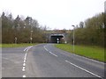
Bere Regis, underpass
Taking the Bere Regis to Milborne St Andrew road under A35(T).
Image: © Mike Faherty
Taken: 26 Feb 2013
0.10 miles
10
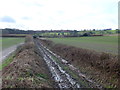
Bridle Path at Shitterton
This very muddy bridle path leads from Shitterton up onto Black Hill. On some OS maps the name of the hamlet has been Bowdlerised to Sitterton and there is a Sitterton Close nearby.
Image: © Nigel Mykura
Taken: 1 Feb 2013
0.11 miles