IMAGES TAKEN NEAR TO
Cocknowle, WAREHAM, BH20 5NT
Introduction
This page details the photographs taken nearby to BH20 5NT by members of the Geograph project.
The Geograph project started in 2005 with the aim of publishing, organising and preserving representative images for every square kilometre of Great Britain, Ireland and the Isle of Man.

There are currently over 7.5m images from over14,400 individuals and you can help contribute to the project by visiting https://www.geograph.org.uk
Image Map
Images are licensed for reuse under creativecommons.org/licenses/by-sa/2.0
Notes
- Clicking on the map will re-center to the selected point.
- The higher the marker number, the further away the image location is from the centre of the postcode.
Image Listing (28 Images Found)
Images are licensed for reuse under creativecommons.org/licenses/by-sa/2.0
Image
Details
Distance
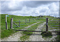
3
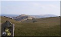
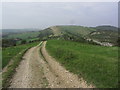
Knowle Hill
Looking south from the Purbeck Ridge towards the coast.
Image: © Pierre Terre
Taken: 6 Sep 2009
0.07 miles
4
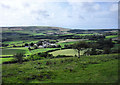
Stonehill Down Nature Reserve
High on the chalk ridge running west/east across the Isle of Purbeck, this downland reserve has far-reaching views, with Poole Harbour to the east. Looking across the reserve we can see Knowle Hill then West Hill which drops down to its lowest point at Corfe Castle. We then climb Brenscombe Hill onward to Nine Barrow Down which points in the direction of Swanage.
Image: © Peter Elsdon
Taken: 13 Mar 2010
0.08 miles
6
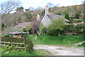
Cocknowle Quarry: Church Knowle, Dorset
This now barely recognizable quarry was operated from 1875 until around 1912 to supply chalk to the Wareham Cement Works at Ridge (Image). The chalk dips northward at around 60° and the Lower Chalk has a narrow outcrop between the edge of the ridge and the Upper Greensand that crops out below at around the level of the house. The quarry extended half a kilometre along the ridge. Chalk was moved to the base of the ridge on the north side (Image) by means of a tramway (see Image) then by horse and cart to Ridge (7 km). The active quarry to the north of the ridge is modern. For more details, see http://www.cementkilns.co.uk/cement_kiln_wareham.html.
Image: © Dylan Moore
Taken: 28 Jul 2010
0.10 miles
7
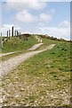
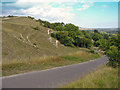
Ridgeway, Knowle Hill
The footpath heads west towards Ridgeway Hill.
Image: © Pierre Terre
Taken: 6 Sep 2009
0.11 miles
8
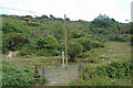
Site of tramway near Church Knowle, Dorset
The embankment in the foreground was the end of a tramway that moved chalk across the ridge to supply the Wareham Cement Works at Image The tramway descended diagonally across the picture from the left top corner. There was no road over the ridge 100 years ago. An 1882 newspaper article says "marl is lowered by means of a double action drum, saving many miles of cartage by way of Corfe Castle". See Image
Image: © Dylan Moore
Taken: 28 Jul 2010
0.13 miles
9
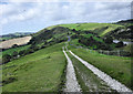
Ridgeway to Corfe Castle
The path heading east.
Image: © Pierre Terre
Taken: 6 Sep 2009
0.14 miles
10
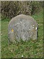
Modern Milestone at Bare Cross, Church Knowle Parish
Dorset Path Marker by the path, in parish of Church Knowle (Purbeck District), Bare Cross, at junction of paths, on wide grass verge.
Surveyed
Milestone Society National ID: DO_DNPMB
Image: © Milestone Society
Taken: Unknown
0.14 miles